Langley
sc̓q̓abac | |
|---|---|
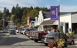
 Main Street in Langley | |
| Nickname: "The Village by the Sea" | |
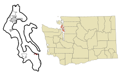
 Location of Langley in Washington | |
| Coordinates: 48°2′12.92″N 122°24′30.6″W / 48.0369222°N 122.408500°W | |
| Country | United States |
| State | Washington |
| County | Island |
| Incorporated | February 26, 1913 |
| Government | |
| • Type | Mayor-council government with 5 council members |
| • Mayor | Scott Chaplin |
| Area | |
| • City | 1.58 sq mi (4.09 km2) |
| • Land | 1.01 sq mi (2.61 km2) |
| • Water | 0.57 sq mi (1.48 km2) |
| • Metro | 26.2 sq mi (67.86 km2) |
| Elevation | 0–90 ft (0–27.7 m) |
| Population (2020) | |
| • City | 1,147 |
| • Density | 730/sq mi (280/km2) |
| Time zone | UTC-8 (PST) |
| • Summer (DST) | UTC-7 (PDT) |
| ZIP code | 98260 |
| Area code | 360 564 |
| Telephone exchanges | 221, 321, 331, 341, 730 |
| FIPS code | 53-38355[2] |
| GNIS feature ID | 1512376[3] |
| Annual budget | 2012, approximately $5.5 million |
| Website | City of Langley |

Langley (Lushootseed: sc̓q̓abac)[4][5][6] is a city in Island County, Washington, United States. It sits at the south end of Whidbey Island, overlooking the Saratoga Passage. The city's population was 1,035 at the 2010 census, while the ZIP Code Tabulation Area (ZCTA) for Langley's post office had a population of 4,878.[7] By the 2020 census, the population increased to 1,147 people.[8] Langley proper only covers 0.8 square miles (2.1 km2), but its ZCTA extends for 26.20 square miles (67.9 km2).[7]
Langley has been home to the Snohomish people since time immemorial. For centuries, people came to the site of Langley to camp during the summer months, and there was a village nearby at Sandy Point (Lushootseed: č̓əč̓ɬqs), which, as of 1792, was inhabited by about 200 people; however, the Snohomish were removed to the Tulalip Reservation in the late 1800s, and the village was abandoned. The modern settlement of Langley was founded in the 1890s by Jacob Anthes, and the town was incorporated in 1913.
Langley is served by South Whidbey Fire/Emergency Medical Services, the Langley Police Department, and South Whidbey School District #206; the school district offices are located there.
- ^ "2019 U.S. Gazetteer Files". United States Census Bureau. Retrieved August 7, 2020.
- ^ "U.S. Census website". United States Census Bureau. Retrieved January 31, 2008.
- ^ "Langley". Geographic Names Information System. United States Geological Survey, United States Department of the Interior.
- ^ Bates, Dawn; Hess, Thom; Hilbert, Vi (1994). Lushootseed Dictionary. Seattle: University of Washington Press. pp. 53, 64, 71. ISBN 978-0-295-97323-4. OCLC 29877333.
- ^ Waterman, T. T. (2001). sdaʔdaʔ gʷəɬ dibəɬ ləšucid ʔacaciɬtalbixʷ - Puget Sound Geography. Lushootseed Press. p. 364. ISBN 979-8750945764.
- ^ Tweddell, Colin E. (August 1953). A Historical and Ethnological Study of the Snohomish Indian People: A Report Specifically Covering Their Aboriginal and Continued Existence, and Their Effective Occupation of a Definable Territory. Coast Salish and Western Washington Indians. Vol. II. New York & London: Garland Publishing (published 1974). p. 141.
- ^ a b Cite error: The named reference
wwwcensusgovwas invoked but never defined (see the help page). - ^ "Census Bureau profile: Langley, Washington". United States Census Bureau. May 2023. Retrieved May 10, 2024.
