Lanivet
| |
|---|---|
 Lanivet village | |
Location within Cornwall | |
| Population | 1,959 (Civil Parish, 2011) |
| OS grid reference | SX039642 |
| Civil parish |
|
| Unitary authority | |
| Ceremonial county | |
| Region | |
| Country | England |
| Sovereign state | United Kingdom |
| Post town | BODMIN |
| Postcode district | PL30 |
| Dialling code | 01208 |
| Police | Devon and Cornwall |
| Fire | Cornwall |
| Ambulance | South Western |
| UK Parliament | |
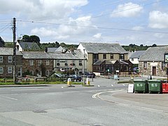
Lanivet (Cornish: Lanneves[1]) is a village and civil parish in Cornwall, England, United Kingdom. The village is situated approximately 2+1⁄2 miles (4.0 km) southwest of Bodmin,[2] and before the Bodmin by-pass was built, the A30 road between London and Land's End passed through the village. The Saints' Way long-distance footpath passes Lanivet near its half-way point.
The parish includes the hamlets of Bodwanick, Bokiddick, Lamorick, St Ingunger, Trebell, Tregullon, Tremore, and Woodly. Part of St Lawrence is also in this parish. An electoral ward of the same name surrounds Bodmin. Its population at the 2011 census was 4,241.[3]
- ^ "List of Place-names agreed by the MAGA Signage Panel" (PDF). Cornish Language Partnership. May 2014. Archived from the original (PDF) on 29 July 2014. Retrieved 11 January 2015.
- ^ Ordnance Survey: Landranger map sheet 200 Newquay & Bodmin ISBN 978-0-319-22938-5
- ^ "Ward population 2011". Retrieved 6 February 2015.
