Lansford, Pennsylvania | |
|---|---|
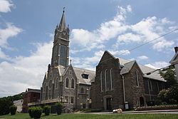
 St. Katharine Drexel Church in the Lansford Historic District in July 2013 | |
 Location of Lansford in Carbon County, Pennsylvania | |
Location of Lansford in Pennsylvania | |
| Coordinates: 40°49′53″N 75°53′0″W / 40.83139°N 75.88333°W | |
| Country | United States |
| State | Pennsylvania |
| County | Carbon |
| Borough (Pennsylvania) | c. 1827 along with Coaldale, Pennsylvania |
| Area | |
| • Total | 1.54 sq mi (3.98 km2) |
| • Land | 1.54 sq mi (3.98 km2) |
| • Water | 0.00 sq mi (0.00 km2) |
| Elevation | 1,145 ft (349 m) |
| Population | |
| • Total | 4,141 |
| • Density | 2,695.96/sq mi (1,040.68/km2) |
| Time zone | UTC-5 (EST) |
| • Summer (DST) | UTC-4 (EDT) |
| ZIP Code | 18232 |
| Area codes | 570 |
| FIPS code | 42-41464 |
| Website | www |
Lansford is a county-border borough (town) in Carbon County, Pennsylvania, United States. It is part of Northeastern Pennsylvania. It is located 37 miles (60 km) northwest of Allentown and 19 miles south of Hazleton in the Panther Creek Valley about 72 miles (116 km) from Philadelphia and abutting the cross-county sister-city of Coaldale in Schuylkill County.
The whole valley was owned and subdivided into separate lots by the historically important Lehigh Coal & Navigation Company, locally called the Old Company, which likely settled some structures on the lands by 1827.[a]
Lansford grew with the development of local anthracite coal mines and was named after Asa Lansford Foster, who was an advocate for merging the small patch towns that developed in the area surrounding the anthracite coal mines.
The population was 3,941 at the 2010 census, a steep decline from a high of 9,632 at the 1930 census common to many mining towns in Northeastern Pennsylvania.[4]
- ^ "ArcGIS REST Services Directory". United States Census Bureau. Retrieved October 12, 2022.
- ^ Cite error: The named reference
USCensusDecennial2020CenPopScriptOnlywas invoked but never defined (see the help page). - ^ David Kuchta citing Joseph Henry Zerbey (12 March 1934). "The History of Coaldale, PA. (1827)". History of Pottsville and Schuylkill County.
- ^ Marsh, Ben (1987). "Continuity and Decline in the Anthracite Towns of Pennsylvania" (PDF). Annals of the Association of American Geographers. 77 (3): 337–352. doi:10.1111/j.1467-8306.1987.tb00163.x. Retrieved 1 January 2014.
Cite error: There are <ref group=lower-alpha> tags or {{efn}} templates on this page, but the references will not show without a {{reflist|group=lower-alpha}} template or {{notelist}} template (see the help page).

