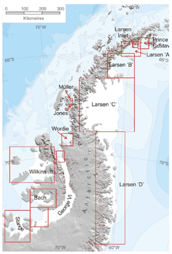
Larsen Ice Shelf | |
|---|---|
 Larsen Ice Shelves A, B, C, and D | |
 | |
| Coordinates: 67°30′S 62°30′W / 67.500°S 62.500°W | |
| Location | Antarctica |
| Part of | Antarctic Peninsula |
| Offshore water bodies | Weddell Sea |
| Etymology | Carl Anton Larsen, captain of the vessel Jason |
| Area | |
| • Total | 26,000 square miles (67,000 km2) |
The Larsen Ice Shelf is a long ice shelf in the northwest part of the Weddell Sea, extending along the east coast of the Antarctic Peninsula[1] from Cape Longing to Smith Peninsula. It is named after Captain Carl Anton Larsen, the master of the Norwegian whaling vessel Jason, who sailed along the ice front as far as 68°10' South during December 1893.[2] In finer detail, the Larsen Ice Shelf is a series of shelves that occupy (or occupied) distinct embayments along the coast. From north to south, the segments are called Larsen A (the smallest), Larsen B, and Larsen C (the largest) by researchers who work in the area.[3] Further south, Larsen D and the much smaller Larsen E, F and G are also named.[4]
The breakup of the ice shelf since the mid-1990s has been widely reported,[5] with the collapse of Larsen B in 2002 being particularly dramatic. A large section of the Larsen C shelf broke away in July 2017 to form an iceberg known as A-68.[6]
The ice shelf originally covered an area of 85,000 square kilometres (33,000 sq mi), but following the disintegration in the north and the break away of iceberg A-17, it now covers an area of 67,000 square kilometres (26,000 sq mi).[1]
- ^ a b "Larsen Ice Shelf". Encyclopaedia Britannica.
- ^ U.S. Geological Survey Geographic Names Information System: Larsen Ice Shelf
- ^ Cite error: The named reference
SciAm2012was invoked but never defined (see the help page). - ^ Rignot, E; Jacobs, S; Mouginot, J; Scheuchl, B (13 June 2013). "Ice Shelf Melting Around Antarctica" (PDF). Science. 341 (6143): 266–270. Bibcode:2013Sci...341..266R. doi:10.1126/science.1235798. PMID 23765278. S2CID 206548095. Retrieved 21 January 2017.
- ^ Chris Wickham (9 May 2012). "Warm water threatens vast Antarctic ice shelf (+video)". The Christian Science Monitor / Reuters. Retrieved 20 January 2017.
- ^ "Iceberg four times the size of London breaks off from Antarctica ice shelf". The Daily Telegraph. 12 July 2017.