You can help expand this article with text translated from the corresponding article in French. (December 2008) Click [show] for important translation instructions.
|
Laruns | |
|---|---|
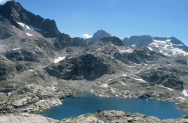
 Arrémoulit Lakes | |
| Coordinates: 42°58′59″N 0°24′58″W / 42.983°N 0.416°W | |
| Country | France |
| Region | Nouvelle-Aquitaine |
| Department | Pyrénées-Atlantiques |
| Arrondissement | Oloron-Sainte-Marie |
| Canton | Oloron-Sainte-Marie-2 |
| Intercommunality | Vallée d'Ossau |
| Government | |
| • Mayor (2020–2026) | Robert Casadebaig[1] |
| Area 1 | 248.96 km2 (96.12 sq mi) |
| Population (2021)[2] | 1,180 |
| • Density | 4.7/km2 (12/sq mi) |
| Time zone | UTC+01:00 (CET) |
| • Summer (DST) | UTC+02:00 (CEST) |
| INSEE/Postal code | 64320 /64440 |
| Elevation | 458–2,973 m (1,503–9,754 ft) (avg. 536 m or 1,759 ft) |
| 1 French Land Register data, which excludes lakes, ponds, glaciers > 1 km2 (0.386 sq mi or 247 acres) and river estuaries. | |

Laruns (French pronunciation: [laʁœ̃s];[3][4][5] Occitan: Laruntz) is a commune in the Pyrénées-Atlantiques department in south-western France.[6]
It is situated at the confluence of two mountain streams, the Gave d'Ossau and its tributary, the Valentin.[7]
Formerly part of the province of Béarn, Laruns is now within the département of Pyrénées-Atlantiques, itself in France's Nouvelle-Aquitaine région. It forms part of the arrondissement of Oloron-Sainte-Marie, and of the canton of Oloron-Sainte-Marie-2.[6]
- ^ "Répertoire national des élus: les maires" (in French). data.gouv.fr, Plateforme ouverte des données publiques françaises. 13 September 2022.
- ^ "Populations légales 2021" (in French). The National Institute of Statistics and Economic Studies. 28 December 2023.
- ^ France 3 Nouvelle-Aquitaine. "" Tous les chemins mènent à vous " à Laruns dans les Pyrénées-Atlantiques". YouTube.
{{cite web}}: CS1 maint: numeric names: authors list (link) - ^ France 3 Nouvelle-Aquitaine. "Fêtes de Laruns 2019". YouTube.
{{cite web}}: CS1 maint: numeric names: authors list (link) - ^ France 3 Nouvelle-Aquitaine. "Laruns attend son tour de France avec impatience". YouTube.
{{cite web}}: CS1 maint: numeric names: authors list (link) - ^ a b INSEE commune file
- ^ Reynolds, Kev (2004). The Pyrenees: The High Pyrenees from the Cirque De Lescun to the Carlit Massif. Cicerone Press. p. 132. ISBN 1-85284-420-5.


