Launay | |
|---|---|
 | |
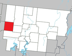
 Location within Abitibi RCM | |
| Coordinates: 48°39′N 78°32′W / 48.650°N 78.533°W[1] | |
| Country | Canada |
| Province | Quebec |
| Region | Abitibi-Témiscamingue |
| RCM | Abitibi |
| Settled | c. 1917 |
| Constituted | May 18, 1921 |
| Named for | Jean-Baptiste Leporquier de Launay[1] |
| Government | |
| • Mayor | Claudette Laroche |
| • Federal riding | Abitibi—Témiscamingue |
| • Prov. riding | Abitibi-Ouest |
| Area | |
| • Total | 259.22 km2 (100.09 sq mi) |
| • Land | 257.80 km2 (99.54 sq mi) |
| Population (2021)[3] | |
| • Total | 211 |
| • Density | 0.8/km2 (2/sq mi) |
| • Pop (2016-21) | |
| • Dwellings | 99 |
| Time zone | UTC−5 (EST) |
| • Summer (DST) | UTC−4 (EDT) |
| Postal code(s) | |
| Area code | 819 |
| Highways | |
| Website | www |
Launay is a township municipality in the Canadian province of Quebec, located in the Abitibi Regional County Municipality.
The municipality is named after Jean-Baptiste Leporquier de Launay, a military commander and captain of the Guyenne Regiment from the mid-18th century.[1]
Its economy is dependent on agriculture and forestry.[1]
- ^ a b c d Cite error: The named reference
toponymiewas invoked but never defined (see the help page). - ^ a b "Launay". Répertoire des municipalités (in French). Ministère des Affaires municipales et de l'Habitation. Retrieved 2023-07-28.
- ^ a b "Launay, Quebec (Code 2488080) Census Profile". 2021 census. Government of Canada - Statistics Canada.
