Lavras | |
|---|---|
| Municipality of Lavras | |
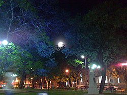
 Moonlight at Dr. Augusto Silva Square | |
| Etymology: Mining and tillage | |
| Nickname(s): Cidade dos Ipês e das Escolas ("City of the Ipês and Schools") | |
| Anthem: Hino do município de Lavras | |
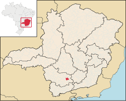
 Location of Lavras | |
| Coordinates: 21°14′42″S 45°00′00″W / 21.24500°S 45.00000°W | |
| Country | |
| Region | Southeast |
| State | |
| Mesoregion | Campo das Vertentes |
| Founded | 1729 |
| Town rights | 1831 |
| Government | |
| • Mayor | Jussara Menicucci de Oliveira (PSB) |
| Area | |
| • Total | 564.495 km2 (217.953 sq mi) |
| Elevation | 919 m (3,015 ft) |
| Population (2022 est.)[1] | |
| • Total | 104,761 |
| • Density | 190/km2 (480/sq mi) |
| Demonym | lavrense |
| Time zone | UTC−3 (BRT) |
| Postal Code | 37200-000 |
| Area code | (+55) 35 |
| Website | lavras |
Lavras is a municipality in southern Minas Gerais state, Brazil. Located at an altitude of 919 m, it has a population of 104,761 inhabitants (2022).[1] The area of the municipality is 564.495 km2. The average annual temperature is 19.6°C and the average annual rainfall is 1,511 millimetres.
Located at the Green Valley and Waterfalls tourist circuit, it is also near Waters circuit – a series of spas in the state of São Paulo and Minas Gerais — and the Inconfidentes Trail circuit – a historical region of Minas. Lavras is connected by highway to the state capital, Belo Horizonte (237 km), to São Paulo (379 km) and Rio de Janeiro (423 km).[2]
- ^ a b "Consulte a população da sua cidade". 2022. Retrieved June 28, 2023.
2022 Estimates of Population
- ^ "Calculadora". Distância entre Cidades. Retrieved January 17, 2016.

