Lawrence, Indiana | |
|---|---|
 Houses along 45th street in Lawrence | |
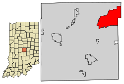
 Location in Marion County, Indiana | |
| Coordinates: 39°52′03″N 85°59′26″W / 39.86750°N 85.99056°W | |
| Country | United States |
| State | Indiana |
| County | Marion |
| Government | |
| • Mayor | Deborah Whitfield (D) |
| • Common Council[1] | Tyrrell Giles (D, 1st) Rick Wells (D, 2nd) Sherron Freeman (D, 3rd) Carlos Jennings (D, 4th) Zach Cramer (D, 5th) Kristina Krone (D, 6th) Lisa Chavis (D, AL) Liz Masur (D, AL) Betty Robinson (D, AL) |
| Area | |
• Total | 20.25 sq mi (52.43 km2) |
| • Land | 20.15 sq mi (52.18 km2) |
| • Water | 0.10 sq mi (0.25 km2) |
| Elevation | 853 ft (260 m) |
| Population | |
• Total | 49,370 |
| • Density | 2,450.37/sq mi (946.11/km2) |
| Time zone | UTC-5 (EST) |
| • Summer (DST) | UTC-4 (EDT) |
| ZIP codes | 46216, 46226, 46235, 46236 |
| Area code(s) | 317, 463 |
| FIPS code | 18-42426[5] |
| GNIS feature ID | 2395647[3] |
| Website | www |


Lawrence is a city in Marion County, Indiana, United States. It is one of four "excluded cities" in Marion County. The city is home to Fort Benjamin Harrison within Fort Harrison State Park. The population was 49,370 at the 2020 census.[4] The city is on the northeast side of Indianapolis.
- ^ "Common Council". City of Lawrence, IN. Retrieved April 22, 2016.
- ^ "2022 U.S. Gazetteer Files: Indiana". United States Census Bureau. Retrieved April 13, 2023.
- ^ a b U.S. Geological Survey Geographic Names Information System: Lawrence, Indiana
- ^ a b "P1. Race – Lawrence city, Indiana: 2020 DEC Redistricting Data (PL 94-171)". U.S. Census Bureau. Retrieved April 13, 2023.
- ^ "US Census website". US Census Bureau. Retrieved January 31, 2008.
