| Lawrence Brook | |
|---|---|
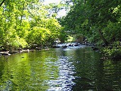
 One of the few undammed sections of Lawrence Brook (below Davidsons Mill Pond) | |
 | |
| Location | |
| Country | United States |
| Physical characteristics | |
| Source | |
| • coordinates | 40°22′33″N 74°32′32″W / 40.37583°N 74.54222°W[1] |
| Mouth | |
• coordinates | 40°29′5″N 74°23′34″W / 40.48472°N 74.39278°W[1] |
• elevation | 3 ft (0.91 m) |
| Basin size | 40 sq mi (100 km2) |
| Basin features | |
| Progression | Raritan River, Atlantic Ocean |
| River system | Raritan River system |
| Tributaries | |
| • left | Terhune Run, Oakeys Brook, Sucker Brook, |
| • right | Great Ditch, Ireland Brook, Beaverdam Brook, Sawmill Brook |

Lawrence Brook is a tributary of the Raritan River in Middlesex County, New Jersey, in the United States.[2]
- ^ a b 139:3:1947447534205058::NO::P3_FID,P3_TITLE:884542%2CLawrence%20Brook "GNIS Detail - Lawrence Brook". USGS. Retrieved 6 July 2010.
{{cite web}}: Check|url=value (help) - ^ Gertler, Edward. Garden State Canoeing, Seneca Press, 2002. ISBN 0-9605908-8-9