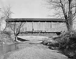
Leatherwood Station Covered Bridge | |
|---|---|
 | |
| Coordinates | 39°45′27.58″N 87°12′33.05″W / 39.7576611°N 87.2091806°W |
| Carries | Walking trail |
| Crosses | Williams Creek (Indiana) |
| Locale | Rockport, Parke, Indiana, United States |
| Official name | Leatherwood Station Covered Bridge |
| Other name(s) | Harry Wolf Bridge |
| Named for | Leatherwood Station |
| Maintained by | Parke County Commissioners Parke County |
| WGCB # | 14-61-25[1] |
| Characteristics | |
| Design | Burr arch truss bridge[2] |
| Total length | 72 ft (21.9 m) (includes 9 ft (2.7 m) overhangs on each end) |
| Width | 16 ft (4.9 m) |
| No. of spans | 1 |
| Clearance above | 14 ft (4.3 m) |
| History | |
| Construction cost | <$680 |
Leatherwood Station Covered Bridge (#25) | |
| Built | 1899 |
| Built by | Joseph A. Britton |
| Website | Leatherwood Station Bridge |
| Part of | Parke County Covered Bridges TR (ID64000193) |
| NRHP reference No. | 78000397 [3] |
| Added to NRHP | December 22, 1978 |
| Location | |
 | |
The Leatherwood Station Covered Bridge is a single span double Burr Arch Truss covered bridge structure that was built by Joseph A. Britton & Son in 1899. Originally it had sandstone abutments but when it was moved to Billie Creek Village they were replaced with concrete abutments with sandstone showing.[4][5]
- ^ Cite error: The named reference
bridgewas invoked but never defined (see the help page). - ^ "Leatherwood Station Covered Bridge (#25)". Parke County Convention & Visitors Commission. Retrieved March 24, 2020.
- ^ "National Register Information System – Leatherwood Station Bridge (#25) (#78000397)". National Register of Historic Places. National Park Service. January 23, 2007. Retrieved March 24, 2020.
- ^ "Leatherwood Station Covered Bridge (#25)". Parke County Incorporated / Parke County Convention and Visitors Commission. Retrieved September 21, 2016.
- ^ "Indiana State Historic Architectural and Archaeological Research Database (SHAARD)" (Searchable database). Department of Natural Resources, Division of Historic Preservation and Archaeology. Retrieved June 1, 2016. Note: This includes Charles Felkner (December 1977). "National Register of Historic Places Inventory Nomination Form: Parke County Covered Bridge Historic District" (PDF). Retrieved June 1, 2016., Site map, and Accompanying photographs.


