This article needs additional citations for verification. (January 2013) |
Leer | |
|---|---|
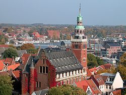
 View of the town hall and harbor | |
Location of Leer within Leer district  | |
| Coordinates: 53°13′51″N 7°27′10″E / 53.23083°N 7.45278°E | |
| Country | Germany |
| State | Lower Saxony |
| District | Leer |
| Subdivisions | 9 Subdivisions |
| Government | |
| • Mayor (2021–26) | Claus-Peter Horst[1] (Ind.) |
| Area | |
| • Total | 70.30 km2 (27.14 sq mi) |
| Elevation | 3 m (10 ft) |
| Population (2022-12-31)[2] | |
| • Total | 35,663 |
| • Density | 510/km2 (1,300/sq mi) |
| Time zone | UTC+01:00 (CET) |
| • Summer (DST) | UTC+02:00 (CEST) |
| Postal codes | 26789 |
| Dialling codes | 0491 |
| Vehicle registration | LER |
| Website | www.leer.de |

Leer (German pronunciation: [leːɐ̯] ) is a town in the district of Leer, in the northwestern part of Lower Saxony, Germany. It is situated on the river Leda,[3] a tributary of the river Ems, near the border with the Netherlands. With 34,958 inhabitants (2021), it is the third-largest city in East Frisia after Emden and Aurich.
It has a railway and autobahn connection to Groningen, Netherlands, Emden, Bremen and the South (Rheine and the Ruhr industrial region).
- ^ "Direktwahlen in Niedersachsen vom 12. September 2021" (PDF). Landesamt für Statistik Niedersachsen. 13 October 2021.
- ^ "LSN-Online Regionaldatenbank, Tabelle A100001G: Fortschreibung des Bevölkerungsstandes, Stand 31. Dezember 2022" (in German). Landesamt für Statistik Niedersachsen.
- ^ Chisholm, Hugh, ed. (1911). . Encyclopædia Britannica. Vol. 16 (11th ed.). Cambridge University Press. p. 370.


