Leesville | |
|---|---|
| Leesville, Texas | |
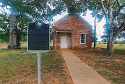
Sandies Creek Iron Rail-Bridge ca. 1899 above;[1] Leesville historical-marker below | |
| Nickname(s): | |
 | |
| Coordinates: 29°24′25″N 97°44′42″W / 29.40694°N 97.74500°W | |
| Granted | 1806 (de la Baume)[11][12] |
| Settled | ca. 1830s-1861 |
| Founded | 1874[8][9] |
| Recognized | ca. 1891 (state law)[10] |
| Founded by | Newburn H. Guinn |
| Named for | Lee Guinn, daughter of founder[7] |
| Precinct | Electoral Precinct 13 |
| Government | |
| • Type | Court of law |
| Area | |
• Total | 32,793 acres (13,271 ha) |
| • Water | .12 sq mi (0.3 km2) |
| Elevation | 377 ft (115 m) |
| Highest elevation (Capote's Knob) | 670 ft (200 m) |
| Population | |
• Total | 384 |
| • Density | 7.5/sq mi (2.9/km2) |
| • Density | 238.8/sq mi (92.2/km2) |
| Time zone | UTC−06:00 (CST) |
| • Summer (DST) | UTC−05:00 (CDT) |
| ZIP code | 78122-9998[18] |
| Location | Southeast Guadalupe County line; West Gonzales County; South of Belmont, north of Nixon, and west of Bebe |
Leesville is an unincorporated city in the Gonzales-Guadalupe County area in Texas, United States.[15] The community had a population of 384 residents as of 2018.[citation needed]
The town was founded in 1874 and was named Leesburg for founder Newburn H. Guinn's daughter, Lee Guinn.[7] The town was renamed Leesville by the U.S. Postal Service and was recognized by state law in 1891.[19]
Leesville is notable for its rich, well-documented history. It is also home to a $149 million water facility and 40-mile pipeline that stores and moves to 11.6 million gallons of water toward the Greater San Antonio area.[20][21]
- ^ "Bridges". Engineering News and American Railway Journal. 41: 72. 1899. Retrieved May 14, 2020.
...Bids are asked...for constructing two iron bridges, one over Sandies Creek...
- ^ "GNIS Detail - Leesville". U.S. Geological Survey. U.S. Department of the Interior. Retrieved May 16, 2020.
Variant Name...Capote...Leesburg...
- ^ "Lubbock Morning Avalanche, 1926". February 17, 1926. Retrieved September 19, 2018.
...State of Texas, being a part of the E. W. Cullen League, in the town of Leesville...
- ^ "Library of Congress; Gonzales County, Texas". Library of Congress. Retrieved September 5, 2018.
- ^ "...Leesville on the E. W. Cullen league..." Archived from the original on September 2, 2018.
- ^ "Postal Bulletin (1996)". University of Michigan; United States Postal Service, Directives Control Division. 1996. Retrieved May 2, 2021.
- ^ a b Davis, Fletcher. The Hondo Anvil Herald. (Hondo, Tex.), Vol. 51, No. 52, Ed. 1 Friday, July 9, 1937, newspaper, July 9, 1937; Hondo, Texas.
- ^ Cite error: The named reference
Leesville Founding2was invoked but never defined (see the help page). - ^ Current name adopted in 1874.
- ^ Neill, Associate Justice. "West v. West, 29 S.W. 242 (Tex. App. 1895)". Court Listener. Court of Appeals of Texas. Retrieved January 30, 2021.
- ^ Muckelroy, Duncan (1974). "History of El Capote Ranch". East Texas Historical Journal. 12 (2). Retrieved May 12, 2020.
- ^ "...The Spanish government made one of the first land grants in the Guadalupe County area to José de la Baume in 1806 for land in the Capote Hills..." Texas State Historical Association. Retrieved September 19, 2018.
- ^ "Area Characteristics". Archived from the original on February 13, 2020. Retrieved August 28, 2018.
- ^ "Capote Hills". TSHA Handbook of Texas. Texas State Historical Association. Retrieved September 9, 2020.
- ^ a b c U.S. Geological Survey Geographic Names Information System: Leesville, Texas
- ^ "384". United States Census Bureau. Retrieved August 15, 2020.
- ^ "Southeast Guadalupe CCD, Guadalupe County, Texas -- Rural". United States Census Bureau. Retrieved August 25, 2020.
- ^ "United States Postal Service". Retrieved December 11, 2018.
- ^ Brown, Sampson Harvey (August 25, 1885). "Marking Device Patent". The Portal to Texas History. Washington, D.C.: United States Patent Office. Retrieved June 15, 2020 – via University of North Texas.
Patent for a new and improved merchandise tag. This design consists of a stick "provided with means for holding it fixed in its position after it has been inserted and having hinged to its outer end the tag having a strip of suitable material secured around its edges, as shown, so as to form on both sides of the tag the flanges adapted to receive the removable, reversible, and interchangeable cards
- ^ DeKunder, David (July 15, 2014). "Schertz-Seguin pipeline transporting San Antonio water". San Antonio Express-News. Hearst Newspapers. Retrieved July 21, 2020.
40-mile pipeline runs from western Gonzales County to Seguin and Schertz, where the water is delivered...
- ^ "Schertz Seguin Local Government Corporation - Groundwater Transmission and Treatment System Gonzales Well Field Project". Groundwater Transmission and Treatment System Gonzales Well Field Project. Walker Partners; Engineers, Surveyors. 2016. Retrieved July 21, 2020.
The decision was made to expand the existing supplies from both Gonzales and Guadalupe groundwater options. This provided the most reliable and cost effective long-term supply.

