Leetonia, Ohio | |
|---|---|
 Main Street in Leetonia looking west. | |
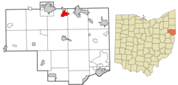
 Location of Leetonia in Columbiana County and in the State of Ohio | |
| Coordinates: 40°52′30″N 80°45′25″W / 40.87500°N 80.75694°W | |
| Country | United States |
| State | Ohio |
| County | Columbiana |
| Government | |
| • Type | Mayor-Council |
| • Mayor | Kevin Siembida (R)[1] |
| Area | |
| • Total | 2.27 sq mi (5.88 km2) |
| • Land | 2.26 sq mi (5.86 km2) |
| • Water | 0.01 sq mi (0.02 km2) |
| Elevation | 1,102 ft (336 m) |
| Population (2020) | |
| • Total | 1,833 |
| • Density | 809.99/sq mi (312.72/km2) |
| Time zone | UTC-5 (Eastern (EST)) |
| • Summer (DST) | UTC-4 (EDT) |
| ZIP code | 44431 |
| Area code(s) | 330, 234 |
| FIPS code | 39-42560[4] |
| GNIS feature ID | 2398413[3] |
| School District | Leetonia Exempted Village School District |
| Website | http://leetonia.org/ |
Leetonia is a village in northern Columbiana County, Ohio, United States. The population was 1,833 at the 2020 census.[5] It is about 15 miles (24 km) south of Youngstown.
- ^ "2020 General Election Results for Columbiana County" (PDF). Retrieved February 19, 2021.
- ^ "ArcGIS REST Services Directory". United States Census Bureau. Retrieved September 20, 2022.
- ^ a b U.S. Geological Survey Geographic Names Information System: Leetonia, Ohio
- ^ "U.S. Census website". United States Census Bureau. Retrieved January 31, 2008.
- ^ "Leetonia village, Ohio". U.S. Census Bureau. Retrieved March 24, 2022.