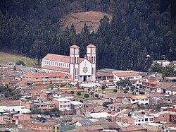
Lenguazaque | |
|---|---|
Municipality and town | |
 | |
 Location of the municipality and town inside Cundinamarca Department of Colombia | |
| Coordinates: 5°18′25″N 73°42′22″W / 5.30694°N 73.70611°W | |
| Country | |
| Department | |
| Province | Ubaté Province |
| Founded | 13 March 1537 |
| Founded by | Gonzalo Jiménez de Quesada |
| Government | |
| • Mayor | Camilo Andrés Lara Gómez (2016-2019) |
| Area | |
| • Municipality and town | 153.6 km2 (59.3 sq mi) |
| Elevation | 2,589 m (8,494 ft) |
| Population (2015) | |
| • Municipality and town | 10,268 |
| • Density | 67/km2 (170/sq mi) |
| • Urban | 2,282 |
| Time zone | UTC-5 (Colombia Standard Time) |
| Website | Official website |
Lenguazaque is a municipality and town of Colombia in the department of Cundinamarca. Lenguazaque is situated on the Altiplano Cundiboyacense, part of the Eastern Ranges of the Colombian Andes at a distance of 116 kilometres (72 mi) from the capital Bogotá.[1] It borders Guachetá in the north, Ubaté in the west, Cucunubá in the south and Villapinzón in the east.
- ^ (in Spanish) Official website Lenguazaque Archived 2015-05-22 at archive.today - accessed 07-05-2016


