| Levisa Fork | |
|---|---|
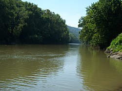
 The Levisa Fork in Paintsville | |
 Map of the Big Sandy River watershed, with its Levisa Fork (left) and Tug Fork (right) tributaries shown | |
| Location | |
| Country | United States |
| State | Kentucky, Virginia |
| Counties | Buchanan VA, Pike KY, Floyd KY, Johnson KY, Lawrence KY |
| Physical characteristics | |
| Source | Gap of Sandy |
| • location | Buchanan County, VA |
| • coordinates | 37°09′06″N 81°54′04″W / 37.15167°N 81.90111°W |
| • elevation | 2,657 ft (810 m)[1] |
| Mouth | Big Sandy River[2] |
• location | Louisa, KY |
• coordinates | 38°07′05″N 82°36′06″W / 38.11806°N 82.60167°W |
• elevation | 545 ft (166 m) |
| Length | 164 mi (264 km)[3] |
| Discharge | |
| • location | Pikeville, KY[4] |
| • average | 1,504 cu ft/s (42.6 m3/s)[4] |
| • minimum | 66 cu ft/s (1.9 m3/s) |
| • maximum | 85,500 cu ft/s (2,420 m3/s) |
The Levisa Fork (also known as the Levisa Fork River or the Levisa Fork of the Big Sandy River) is a tributary of the Big Sandy River, approximately 164 miles (264 km) long,[3] in southwestern Virginia and eastern Kentucky in the United States.
- ^ "Levisa Fork Source". Elevation Query. U.S. Geological Survey. Archived from the original on 2011-07-22. Retrieved 2009-07-18.
- ^ "Levisa Fork". Geographic Names Information System. United States Geological Survey, United States Department of the Interior. 1979-09-20. Retrieved 2009-07-18.
- ^ a b U.S. Geological Survey. National Hydrography Dataset high-resolution flowline data. The National Map Archived 2012-03-29 at the Wayback Machine, accessed June 13, 2011
- ^ a b United States Geological Survey; USGS 03209500 LEVISA FORK AT PIKEVILLE, KY; retrieved July 18, 2009.