Levittown | |
|---|---|
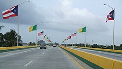
 Bridge on Puerto Rico Highway 165 leaving Levittown | |
Location within the island of Puerto Rico | |
| Coordinates: 18°26′55″N 66°10′49″W / 18.44861°N 66.18028°W | |
| Commonwealth | |
| Area | |
| • Total | 6.6 km2 (2.53 sq mi) |
| • Land | 5.9 km2 (2.27 sq mi) |
| • Water | 0.7 km2 (0.26 sq mi) |
| Elevation | 2 m (5 ft) |
| Population (2020) | |
| • Total | 25,591 |
| • Density | 3,900/km2 (10,000/sq mi) |
| Time zone | UTC-4 (Atlantic (AST)) |
| Postal code | 00949 |
| Area code | 787 |
| FIPS code | 7250260 |
| GNIS feature ID | 2414861 |
Levittown, a suburb in the municipality of Toa Baja, is one of the largest planned communities in Puerto Rico. Per the 2020 census, the population was 25,591.[1] It is divided into eight sections called secciones (the eighth section was renamed Urb. Fronteras) and several sub-divisions called urbanizaciones. Levittown is known for its large, light blue painted water tower (now converted into a public library) that was one of the first water towers in Puerto Rico used to provide potable water to residences.[citation needed]
- ^ "Mansión del Mar comunidad, Puerto Rico". United States Census Bureau. Retrieved April 15, 2022.
