Lewis County | |
|---|---|
 Lewis County Historic Courthouse | |
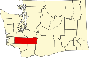
 Location within the U.S. state of Washington | |
 Washington's location within the U.S. | |
| Coordinates: 46°35′N 122°24′W / 46.58°N 122.4°W | |
| Country | |
| State | |
| Founded | December 19, 1845 |
| Named for | Meriwether Lewis |
| Seat | Chehalis |
| Largest city | Centralia |
| Area | |
| • Total | 2,436 sq mi (6,310 km2) |
| • Land | 2,403 sq mi (6,220 km2) |
| • Water | 33 sq mi (90 km2) 1.4% |
| Population (2020) | |
| • Total | 82,149 |
| • Estimate (2022) | 85,370 |
| • Density | 32.5/sq mi (12.5/km2) |
| Time zone | UTC−8 (Pacific) |
| • Summer (DST) | UTC−7 (PDT) |
| Congressional district | 3rd |
| Website | lewiscountywa |
Lewis County is a county in the U.S. state of Washington. As of the 2020 census, the county's population was 82,149.[1] The county seat is Chehalis,[2] and its largest city is Centralia. Lewis County comprises the Centralia, WA Micropolitan Statistical Area, which is also included in the Seattle-Tacoma, WA Combined Statistical Area.
- ^ "State & County QuickFacts". United States Census Bureau. Retrieved August 16, 2023.
- ^ "Find a County". National Association of Counties. Retrieved June 7, 2011.