Liberty City | |
|---|---|
 Liberty City mural | |
| Nickname: Model City (historic name) | |
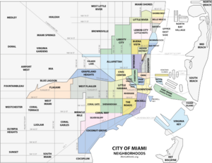
 The Liberty City neighborhood in Miami | |
| Country | |
| State | |
| County | Miami-Dade County |
| City | Miami |
| Government | |
| • City of Miami Commissioner | Jeffrey Watson |
| • Miami-Dade Commissioners | Keon Hardemon |
| • House of Representatives | Ashley V. Gantt (D) and Dotie Joseph (D) |
| • State Senate | Shevrin "Shev" Jones (D) |
| • U.S. House | Frederica Wilson (D) |
| Elevation | 3 m (10 ft) |
| Population (2010) | |
| • Total | 19,725 |
| • Density | 3,733/km2 (9,669/sq mi) |
| Time zone | UTC-05 (EST) |
| ZIP Code | 33125, 33127, 33142, 33147, 33150 |
| Area code(s) | 305, 786 |
Liberty City is a neighborhood in Miami, Florida, United States. The area is roughly bound by NW 79th Street to the north, NW 27th Avenue to the west, the Airport Expressway to the South, and Interstate 95 to the east. The neighborhood is home to one of the largest concentrations of African Americans in South Florida, as of the 2000 census.[1][2] Although it was often known as "Model City" both historically and by the City of Miami government, residents more commonly call it Liberty City.
It is serviced by the Miami Metrorail at Dr. Martin Luther King Jr. Plaza and Brownsville stations along NW 27th Avenue.
- ^ "City of Miami-NET: Model City (Liberty City)" (PDF). www.ci.miami.fl.us. Archived from the original (PDF) on March 29, 2017. Retrieved June 13, 2019.
- ^ Liberty City neighborhood, detailed profile