This article needs additional citations for verification. (July 2009) |
| Lickey | |
|---|---|
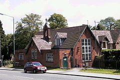
 The old school house, now in use as offices. | |
Location within Worcestershire | |
| OS grid reference | SO999752 |
| Civil parish | |
| District | |
| Shire county | |
| Region | |
| Country | England |
| Sovereign state | United Kingdom |
| Post town | BIRMINGHAM |
| Postcode district | B45 |
| Dialling code | 0121 |
| UK Parliament | |
Lickey is a "linear development" in the north of Worcestershire, England approximately 10 miles (16 km) south west from the centre of Birmingham. It lies in Bromsgrove District and is situated on the Lickey Ridge, amongst the Lickey Hills, its proximity to countryside and the city makes it a popular commuter area. The civil parish of Lickey and Blackwell has a population of 4,140.[1]
The name of Lickey dating back to 1225 is thought to have derived from 'leac' (a clearing) and 'hey' (an enclosed space), including perhaps referring to a clearing in the forest. Various names have included La Lecheye, La Lekeheye, Lechay, Lekhaye. The area forms part of the Lickey Hills Country Park which covers 524 acres.
