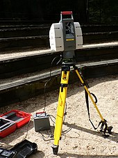


Lidar (/ˈlaɪdɑːr/, also LIDAR, LiDAR or LADAR, an acronym of "light detection and ranging"[1] or "laser imaging, detection, and ranging"[2]) is a method for determining ranges by targeting an object or a surface with a laser and measuring the time for the reflected light to return to the receiver. Lidar may operate in a fixed direction (e.g., vertical) or it may scan multiple directions, in which case it is known as lidar scanning or 3D laser scanning, a special combination of 3-D scanning and laser scanning.[3] Lidar has terrestrial, airborne, and mobile applications.[4][5]
Lidar is commonly used to make high-resolution maps, with applications in surveying, geodesy, geomatics, archaeology, geography, geology, geomorphology, seismology, forestry, atmospheric physics,[6] laser guidance, airborne laser swathe mapping (ALSM), and laser altimetry. It is used to make digital 3-D representations of areas on the Earth's surface and ocean bottom of the intertidal and near coastal zone by varying the wavelength of light. It has also been increasingly used in control and navigation for autonomous cars[7] and for the helicopter Ingenuity on its record-setting flights over the terrain of Mars.[8]
The evolution of quantum technology has given rise to the emergence of Quantum LiDAR, demonstrating higher efficiency and sensitivity when compared to conventional LiDAR systems.[9]
- ^ National Oceanic and Atmospheric Administration (26 February 2021). "What is LIDAR". oceanservice.noaa.gov. US Department of Commerce. Retrieved 15 March 2021.
- ^ Travis S. Taylor (2019). Introduction to Laser Science and Engineering. CRC Press.
- ^ Jie Shan and Charles K. Toth (2018). Topographic Laser Ranging and Scanning: Principles and Processing (2nd ed.). CRC Press.
- ^ "Adoption of gallium-based lidar sensors gathers pace". www.argusmedia.com. 2021-06-29. Retrieved 2021-07-14.
- ^ "Ecologists compare accuracy of Lidar technologies for monitoring forest vegetation: Findings suggest mobile platforms have great potential for monitoring a variety of forest attributes". ScienceDaily. Retrieved 2021-07-14.
- ^ Cracknell, Arthur P.; Hayes, Ladson (2007) [1991]. Introduction to Remote Sensing (2 ed.). London: Taylor and Francis. ISBN 978-0-8493-9255-9. OCLC 70765252.
- ^ Lim, Hazel Si Min; Taeihagh, Araz (2019). "Algorithmic Decision-Making in AVs: Understanding Ethical and Technical Concerns for Smart Cities". Sustainability. 11 (20): 5791. arXiv:1910.13122. doi:10.3390/su11205791.
- ^ "How NASA Designed a Helicopter That Could Fly Autonomously on Mars". IEEE Spectrum. 17 February 2021. Archived from the original on 19 February 2021. Retrieved 19 February 2021.
- ^ Gallego Torromé, Ricardo; Barzanjeh, Shabir (2023). "Advances in quantum radar and quantum LiDAR". Progress in Quantum Electronics. 93: 100497. arXiv:2310.07198. doi:10.1016/j.pquantelec.2023.100497.