Lincoln County | |
|---|---|
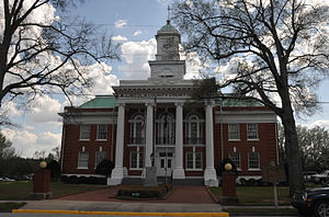
 Lincoln County Courthouse in Lincolnton | |
 Location within the U.S. state of Georgia | |
 Georgia's location within the U.S. | |
| Coordinates: 33°47′N 82°27′W / 33.79°N 82.45°W | |
| Country | |
| State | |
| Founded | February 20, 1796 |
| Named for | Benjamin Lincoln |
| Seat | Lincolnton |
| Largest city | Lincolnton |
| Area | |
• Total | 257 sq mi (670 km2) |
| • Land | 210 sq mi (500 km2) |
| • Water | 47 sq mi (120 km2) 18.2% |
| Population (2020) | |
• Total | 7,690 |
• Estimate (2023) | 7,879 |
| • Density | 30/sq mi (12/km2) |
| Time zone | UTC−5 (Eastern) |
| • Summer (DST) | UTC−4 (EDT) |
| Congressional district | 10th |
| Website | www |
Lincoln County is a county located in the east central portion of the U.S. state of Georgia. As of the 2020 census, the population was 7,690.[1] The county seat is Lincolnton.[2] The county was created on February 20, 1796. Lincoln County is included in the Augusta-Richmond County, GA-SC metropolitan statistical area, the Savannah River forming its northeastern border. Located above the fall line, it is part of the Central Savannah River Area (CSRA) and a member of the CSRA Regional Development Center.
- ^ "Census - Geography Profile: Lincoln County, Georgia". United States Census Bureau. Retrieved December 27, 2022.
- ^ "Find a County". National Association of Counties. Retrieved June 7, 2011.