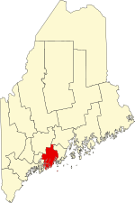
Lincoln County | |
|---|---|
 Lincoln County Courthouse | |
 Location within the U.S. state of Maine | |
 Maine's location within the U.S. | |
| Coordinates: 44°00′49″N 69°32′31″W / 44.013474°N 69.541817°W | |
| Country | |
| State | |
| Founded | 1760 |
| Named for | Lincoln, England |
| Seat | Wiscasset |
| Largest town | Waldoboro |
| Area | |
| • Total | 700 sq mi (2,000 km2) |
| • Land | 456 sq mi (1,180 km2) |
| • Water | 244 sq mi (630 km2) 35% |
| Population (2020) | |
| • Total | 35,237 |
| • Estimate (2023) | 36,507 |
| • Density | 50/sq mi (19/km2) |
| Time zone | UTC−5 (Eastern) |
| • Summer (DST) | UTC−4 (EDT) |
| Congressional district | 1st |
| Website | lincolncountymaine |
Lincoln County is a county located in the U.S. state of Maine. As of the 2020 census, the population was 35,237.[1] Its seat is Wiscasset.[2] The county was founded in 1760 by the Massachusetts General Court from a portion of York County, Massachusetts and named after the English city Lincoln,[3] the birthplace of Massachusetts Bay Provincial Governor Thomas Pownall.[4]
At its founding, Lincoln County accounted for three-fifths of the state's land, and stretched east to Nova Scotia. Thirteen counties were cut out of this land including Sagadahoc County to the west and a portion of Kennebec County to the north.[5] The county flag is a traditional New England flag, adopted in 1977.[6]
- ^ "Census - Geography Profile: Lincoln County, Maine". United States Census Bureau. Retrieved November 21, 2021.
- ^ "Find a County". National Association of Counties. Retrieved June 7, 2011.
- ^ "north by east". Down East: The Magazine of Maine: 19. June 2008.
- ^ "Lincoln County Maine". lincolncountymaine. Retrieved August 25, 2018.
- ^ "Lincoln County information". Archived from the original on September 26, 2009. Retrieved February 11, 2010.
- ^ The Flag of New England Page Archived April 1, 2007, at the Wayback Machine
