Lincolnville, Kansas | |
|---|---|
 Location within Marion County and Kansas | |
 | |
| Coordinates: 38°29′39″N 96°57′41″W / 38.49417°N 96.96139°W[1] | |
| Country | United States |
| State | Kansas |
| County | Marion |
| Township | Clear Creek |
| Platted | 1872, 1887 |
| Incorporated | 1910 |
| Named for | Abraham Lincoln |
| Government | |
| • Type | Mayor–Council |
| • Mayor | Barbara Kaiser |
| Area | |
| • Total | 0.23 sq mi (0.58 km2) |
| • Land | 0.23 sq mi (0.58 km2) |
| • Water | 0.00 sq mi (0.00 km2) |
| Elevation | 1,424 ft (434 m) |
| Population | |
| • Total | 168 |
| • Density | 730/sq mi (290/km2) |
| Time zone | UTC-6 (CST) |
| • Summer (DST) | UTC-5 (CDT) |
| ZIP code | 66858 |
| Area code | 620 |
| FIPS code | 20-41325 |
| GNIS ID | 2395715[1] |
| Website | City website |
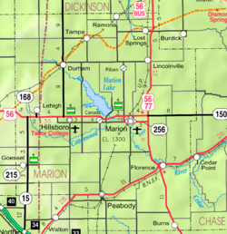
Lincolnville is a city in Marion County, Kansas, United States.[1] As of the 2020 census, the population of the city was 168.[3] The city was named after Abraham Lincoln, the 16th president of the United States. It is located northeast of Marion, west of the intersection of U.S. Route 77 (aka U.S. Route 56) highway and 290th Street next to the Union Pacific Railroad.
- ^ a b c d U.S. Geological Survey Geographic Names Information System: Lincolnville, Kansas
- ^ "2019 U.S. Gazetteer Files". United States Census Bureau. Retrieved July 24, 2020.
- ^ a b "Profile of Lincolnville, Kansas in 2020". United States Census Bureau. Archived from the original on November 11, 2021. Retrieved November 11, 2021.