Linwood, Kansas | |
|---|---|
 Aerial view of Linwood (2017) | |
 Location within Leavenworth County and Kansas | |
 | |
| Coordinates: 39°00′07″N 95°02′11″W / 39.00194°N 95.03639°W[1] | |
| Country | United States |
| State | Kansas |
| County | Leavenworth |
| Founded | 1860s |
| Platted | 1867 |
| Incorporated | 1895 [2] |
| Named for | Linden tree |
| Area | |
| • Total | 0.60 sq mi (1.56 km2) |
| • Land | 0.58 sq mi (1.51 km2) |
| • Water | 0.02 sq mi (0.05 km2) |
| Elevation | 804 ft (245 m) |
| Population | |
| • Total | 415 |
| • Density | 690/sq mi (270/km2) |
| Time zone | UTC-6 (CST) |
| • Summer (DST) | UTC-5 (CDT) |
| ZIP code | 66052 |
| Area code | 913 |
| GNIS ID | 2395727[1] |
| Website | cityoflinwood.org |
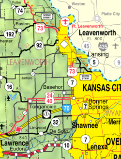
Linwood is a city in Leavenworth County, Kansas, United States,[1] and part of the Kansas City metropolitan area.[5] As of the 2020 census, the population of the city was 415.[4] It is located along K-32 highway between Lawrence and Bonner Springs.
- ^ a b c d U.S. Geological Survey Geographic Names Information System: Linwood, Kansas
- ^ a b "City of Linwood". The League of Kansas Municipalities. May 29, 2019.
- ^ "2019 U.S. Gazetteer Files". United States Census Bureau. Retrieved July 24, 2020.
- ^ a b "Profile of Linwood, Kansas in 2020". United States Census Bureau. Archived from the original on November 19, 2022. Retrieved November 19, 2022.
- ^ "Population Data and Maps | MARC". Archived from the original on September 16, 2014. Retrieved October 14, 2019.