| Little Tennessee River | |
|---|---|
 Little Tennessee River in North Carolina | |
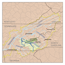
 Little Tennessee River watershed | |
| Location | |
| Country | United States |
| State | Georgia, North Carolina, Tennessee |
| Physical characteristics | |
| Source | Keener Creek |
| • location | Rabun County, Georgia |
| • coordinates | 34°57′36″N 83°27′53″W / 34.96000°N 83.46472°W[1] |
| • elevation | 3,240 ft (990 m) |
| 2nd source | Billy Creek |
| • location | Rabun County, Georgia |
| • coordinates | 34°55′17″N 83°27′04″W / 34.92139°N 83.45111°W[2] |
| • elevation | 2,640 ft (800 m) |
| Source confluence | |
| • location | Rabun County, Georgia |
| • coordinates | 34°55′49″N 83°26′11″W / 34.93028°N 83.43639°W[3][4] |
| • elevation | 2,169 ft (661 m) |
| Mouth | Tennessee River |
• location | Lenoir City, Tennessee |
• coordinates | 35°46′57″N 84°15′28″W / 35.78250°N 84.25778°W[3] |
• elevation | 741 ft (226 m)[3] |
| Length | 135 mi (217 km)[5] |
| Basin size | 2,627 sq mi (6,800 km2)[6] |
| Discharge | |
| • location | Tallassee, Tennessee (below Chilhowee Dam), 33 miles (53 km) above the mouth(mean for water years 1958–1979)[7] |
| • average | 5,012 cu ft/s (141.9 m3/s)(mean for water years 1958–1979)[7] |
| • minimum | 20 cu ft/s (0.57 m3/s)October 1974[7] |
| • maximum | 41,500 cu ft/s (1,180 m3/s)May 1973[7] |
| Basin features | |
| River system | Tennessee → Ohio → Mississippi |
| Tributaries | |
| • left | Nantahala River, Cheoah River, Citico Creek, Tellico River |
| • right | Tuckasegee River, Hazel Creek, Abrams Creek |
The Little Tennessee River (known locally as the Little T) is a 135-mile (217 km) tributary of the Tennessee River that flows through the Blue Ridge Mountains from Georgia, into North Carolina, and then into Tennessee, in the southeastern United States. It drains portions of three national forests— Chattahoochee, Nantahala, and Cherokee— and provides the southwestern boundary of the Great Smoky Mountains National Park.
Numerous dams were erected on the river in the 20th century for flood control and hydropower generation. The river flows through five major impoundments: Fontana Dam, Cheoah Dam, Calderwood Dam, Chilhowee Dam, and Tellico Dam, and one smaller impoundment, Porters Bend Dam.
- ^ U.S. Geological Survey Geographic Names Information System: Keener Creek
- ^ U.S. Geological Survey Geographic Names Information System: Billy Creek
- ^ a b c U.S. Geological Survey Geographic Names Information System: Little Tennessee River
- ^ Adrian Holt, Coweeta LTER, and Little Tennessee Watershed Association, "Upper Little Tennessee Watershed Water and Habitat Quality Education Curriculum," Coweeta Longterm Ecological Research (LTER) website. Retrieved: 4 June 2015.
- ^ Marcos Luna, The Environment Since 1945 (Infobase Learning, 2012), p. 161.
- ^ U.S. Geological Survey, "Introduction to the Upper Tennessee River Basin," 11 January 2013. Accessed: 31 May 2015.
- ^ a b c d United States Geological Survey, Water Resources Data Tennessee: Water Year 1979, Water Data Report TN-79-1, p. 192. Gaging station 03518300 (discontinued in 1979).