Llanddewi Velfrey
| |
|---|---|
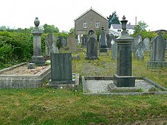
 Bethel Chapel, Llanddewi Velfrey | |
Location within Pembrokeshire | |
| Population | 393 |
| Principal area | |
| Country | Wales |
| Sovereign state | United Kingdom |
| Post town | WHITLAND |
| Postcode district | SA34 |
| Post town | NARBERTH |
| Postcode district | SA67 |
| Police | Dyfed-Powys |
| Fire | Mid and West Wales |
| Ambulance | Welsh |
| UK Parliament | |
| Senedd Cymru – Welsh Parliament | |
Llanddewi Velfrey or Llandewi Velfrey (also Llan-ddewi-vel-vre) (Welsh: Llanddewi Efelffre) is a village, parish and community of Pembrokeshire in West Wales. Historically it was in the Narberth Hundred. The village is in Lampeter Vale, 2 miles (3 km) northeast of Narberth along the A40.[1][2] In 1831 it had a population of 710 people.[1] In 2011 the population was 393.[3]
The village is situated in a rich and fertile vale, watered by the river Tâf, which separates the parish from that of Llangain in the county of Carmarthen. The lands are wholly enclosed and in a good state of cultivation, and the soil is eminently fertile.[1]
- ^ a b c Lewis, Samuel (1833). A Topographical Dictionary of Wales. Lewis and Co. Retrieved 17 June 2012.
- ^ Vay, Benedict Le (18 August 2009). Britain from the Rails: A Window Gazer's Guide. Bradt Travel Guides. p. 164. ISBN 978-1-84162-277-4. Retrieved 17 June 2012.
- ^ "Custom report - Nomis - Official Labour Market Statistics".
