Llano Estacado
"Staked Plains"[1] | |
|---|---|
Southwestern United States | |
 Northwest escarpment of the Llano Estacado | |
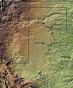
 Shaded relief image of the Llano Estacado. The escarpments marking the eastern edge of the Llano are visible, running roughly in a north–south line through the middle of the Panhandle. The western edge is on the New Mexico side of the border, with the Texas–New Mexico border running considerably closer to the western edge of the Llano than to the eastern. | |
| Coordinates: 33°N 102°W / 33°N 102°W | |
| Country | |
| State | New Mexico and Texas |
| Area | |
| • Total | 83,000 km2 (32,000 sq mi) |
| Population (2013) | |
| • Total | 1,230,000 |
| • Density | 15/km2 (38/sq mi) |
The Llano Estacado (Spanish: [ˈʝano estaˈkaðo]), sometimes translated into English as the Staked Plains,[2] is a region in the Southwestern United States that encompasses parts of eastern New Mexico and northwestern Texas. One of the largest mesas or tablelands on the North American continent,[2] the elevation rises from 3,000 feet (900 m) in the southeast to over 5,000 feet (1,500 m) in the northwest, sloping almost uniformly at about 10 feet per mile (2 m/km).[3]
- ^ Cummins, W.F., 1892. Report on the geography, topography, and geology of the Llano Estacado or Staked Plains with notes on the geology of the country west of the Plains. In: Dumble, E.T. (Ed.), Third annual report of the Geological Survey of Texas 1891. Austin: Henry Hutchings, State Printer, pp. 129-223.
- ^ a b Leatherwood, Art (June 15, 2010). "Llano Estacado". Handbook of Texas Online. Texas State Historical Association.
- ^ Wendorf, F., 1961. Paleoecology of the Llano Estacado, Vol. 1, Santa Fe: NM, The Museum of New Mexico Press, Fort Burgwin Research Center Publication