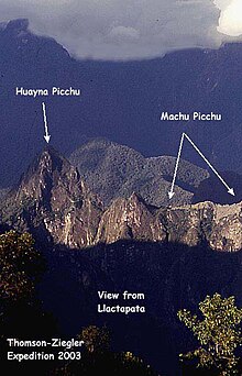
 View of Machu Picchu from Llaqtapata | |
| Location | Peru, Cusco Region, La Convención Province, Santa Teresa District |
|---|---|
| Region | Andes |
| Coordinates | 13°11′9.2″S 72°35′5.1″W / 13.185889°S 72.584750°W |
| History | |
| Cultures | Inca |
Llaqtapata (Quechua) llaqta place (village, town, city, country, nation), pata elevated place / above, at the top / edge, bank (of a river), shore,[1][2][3][4] pronounced 'yakta-pahta',[5] Hispanicized Llactapata) is an archaeological site about 5 km (3.1 mi) east of Machu Picchu. The complex is located in the Cusco Region, La Convención Province, Santa Teresa District, high on a ridge between the Ahobamba and Santa Teresa drainages.[6]
- ^ Teofilo Laime Ajacopa, Diccionario Bilingüe Iskay simipi yuyayk'ancha, La Paz, 2007 (Quechua-Spanish dictionary): llaqta - s País. Nación, región, provincia o territorio, pueblo pequeño. || s. Nación. Conjunto de los habitantes de un territorio. || s. Patria. Lugar, ciudad o país en que se ha nacido. || s. Pueblo. || s. Urbe. Ciudad, en especial populosa. pata - adj. Sitio elevado. / adv. Encima. Más arriba. / s. Orilla. Borde, canto, margen, ribera
- ^ In the final position it is the noun.
- ^ Lost City of the Incas. by Hiram Bingham. 1952. The Orion Publishing Group Ltd, Orion House. page 164. ISBN 0-297-60759-6
- ^ "Chapter X - Searching for the Last Inca Capital". Inca Land - Explorations in the Highlands of Peru - by Hiram Bingham. Retrieved 2011-06-27.
- ^ Explore the Inca Trail. Rucksack Readers. 2006. page 61.
- ^ escale.minedu.gob.pe - UGEL map of the La Convención Province (Cusco Region) showing the rivers Ahobamba, Santa Teresa and Machu Picchu
