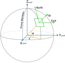
Local tangent plane coordinates (LTP) are part of a spatial reference system based on the tangent plane defined by the local vertical direction and the Earth's axis of rotation. They are also known as local ellipsoidal system,[1][2] local geodetic coordinate system,[3] local vertical, local horizontal coordinates (LVLH), or topocentric coordinates. It consists of three coordinates: one represents the position along the northern axis, one along the local eastern axis, and one represents the vertical position. Two right-handed variants exist: east, north, up (ENU) coordinates and north, east, down (NED) coordinates. They serve for representing state vectors that are commonly used in aviation and marine cybernetics.
- ^ Torge, Wolfgang; Müller, Jürgen (2012-05-29). Geodesy. DE GRUYTER. doi:10.1515/9783110250008. ISBN 978-3-11-020718-7.
- ^ Seeber, Günter (2003-06-19). Satellite Geodesy. Walter de Gruyter. doi:10.1515/9783110200089. ISBN 978-3-11-017549-3.
- ^ "Geodesy". GPS Satellite Surveying. Hoboken, NJ, USA: John Wiley & Sons, Inc. 2015-04-11. pp. 129–206. doi:10.1002/9781119018612.ch4. ISBN 978-1-119-01861-2.