| Loch Eriboll | |
|---|---|
 | |
| Location | Scotland |
| Coordinates | 58°30′18″N 4°40′12″W / 58.505°N 4.670°W |
| Type | Sea loch |
| Basin countries | Scotland |
| Loch Eriboll Lighthouse Whiten Head | |
 Loch Eriboll Lighthouse on the East side of Loch Eriboll. | |
| Coordinates | 58°31′00″N 4°38′54″W / 58.516804°N 4.648422°W |
| Constructed | 1894 (first) |
| Construction | skeletal tower |
| Automated | 2003 |
| Height | 5 metres (16 ft) |
| Shape | square parallelepiped clad tower with white panels as daymark and light |
| Markings | white tower |
| Operator | Northern Lighthouse Board[1] |
| First lit | 2003 (current) |
| Focal height | 19 metres (62 ft) |
| Range | 13 nmi (24 km; 15 mi) (white), 10 nmi (19 km; 12 mi) (red) |
| Characteristic | Fl WR 10s. |
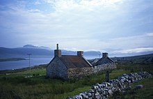
Loch Eriboll (Scottish Gaelic: "Loch Euraboil") is a 16 km (9.9 mi) long sea loch on the north coast of Scotland, which has been used for centuries as a deep water anchorage as it is safe from the often stormy seas of Cape Wrath and the Pentland Firth.
Bronze Age remains can be found in the area, including a souterrain and a very well preserved wheelhouse on the hillside above the west shore. A small scale lime industry developed here in the 19th century and Ard Neakie, a promontory on the eastern shore of the loch, had four large lime kilns developed in around 1870.[2] Before the development of the coast road around the loch in 1890, the Heilam ferry ran from the quay at Portnancon on the west shore to Ard Neakie. Both Ard Neakie and Portnancon were fishing stations.[2][3]

Around the shores of the loch are the crofting townships of Eriboll, Laid, Heilam, Portnancon and Rispond.
Eilean Hoan is located at the northern, seaward end of the loch and there are various small islets in the vicinity including A' Ghoil-sgeir, An Cruachan, An Dubh-sgeir, Eilean Clùimhrig, and Pocan Smoo.[4] Today it is a largely unspoilt wilderness, in a region of high rainfall and with the lowest population density in the UK.
- ^ Rowlett, Russ. "Lighthouses of Scotland: Highlands". The Lighthouse Directory. University of North Carolina at Chapel Hill. Retrieved 17 May 2016.
- ^ a b Ard Neackie, Limekilns, Quarry, Canmore. Retrieved 11 April 2021.
- ^ Loch Eriboll, Undiscovered Scotland. Retrieved 11 April 2021.
- ^ "Get-a-Map". Ordnance Survey. Retrieved 28 November 2009.
