| Lockhart River Queensland | |||||||||||||||
|---|---|---|---|---|---|---|---|---|---|---|---|---|---|---|---|
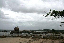
 Quintell Beach in Lockhart River | |||||||||||||||
| Coordinates | 12°47′11″S 143°20′34″E / 12.78639°S 143.34278°E | ||||||||||||||
| Population | 640 (2021 census)[1] | ||||||||||||||
| • Density | 0.1089/km2 (0.2820/sq mi) | ||||||||||||||
| Postcode(s) | 4892 | ||||||||||||||
| Elevation | 17 m (56 ft)[2] | ||||||||||||||
| Area | 5,877.0 km2 (2,269.1 sq mi) | ||||||||||||||
| Location | |||||||||||||||
| LGA(s) | |||||||||||||||
| State electorate(s) | Cook | ||||||||||||||
| Federal division(s) | Leichhardt | ||||||||||||||
| |||||||||||||||
| |||||||||||||||
Lockhart River is a town in the Aboriginal Shire of Lockhart River and a coastal locality split between the Aboriginal Shire of Lockhart River and the Shire of Cook, on the Cape York Peninsula in Queensland, Australia. The town is an Aboriginal community. From 1924 to 1967, the Lockhart River Mission was run by the Anglican Church. In the 2021 census, the locality of Lockhart River had a population of 640 people.[1]
- ^ a b Cite error: The named reference
Census2021was invoked but never defined (see the help page). - ^ Bureau of Meteorology Archived 26 July 2008 at the Wayback Machine Retrieved on 2008-07-05
