| Loddon | |
|---|---|
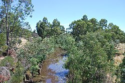
 Loddon River at Newstead | |
| Etymology | After River Loddon[1] |
| Native name |
|
| Location | |
| Country | Australia |
| State | Victoria |
| Region | Riverina bioregion (IBRA), Central Highlands, Loddon Mallee |
| LGAs | Hepburn, Mount Alexander, Loddon, Gannawarra |
| Towns | Newstead, Bridgewater, Serpentine, Kerang |
| Physical characteristics | |
| Source | Great Dividing Range |
| • location | Musk |
| • coordinates | 37°24′19.5″S 144°14′31.5″E / 37.405417°S 144.242083°E |
| • elevation | 638 m (2,093 ft) |
| Mouth | Little Murray River |
• location | Kerang |
• coordinates | 35°33′4.7″S 143°53′0.5″E / 35.551306°S 143.883472°E |
• elevation | 71 m (233 ft) |
| Length | 392 km (244 mi) |
| Basin size | 15,320 km2 (5,920 sq mi) |
| Discharge | |
| • average | 8 m3/s (280 cu ft/s) |
| Basin features | |
| River system | Murray-Darling basin |
| Tributaries | |
| • left | Middleton Creek, Tarilta Creek, Larni Barramal Yaluk (Jim Crow Creek), Joyces Creek, Boundary Gully, Tullaroop Creek, Bet Bet Creek, Bullabul Creek, Hope Creek, Sheepwash Creek |
| • right | Muckleford Creek, Bradford Creek, Little Creek (Loddon), Serpentine Creek, Sangus Creek, Twelve Mile Creek (Loddon), Bannacher Creek |
| Nature reserve | Upper Loddon Flore Reserve |
| [4] | |
The Loddon River, an inland river of the north–central catchment, part of the Murray-Darling basin, is located in the lower Riverina bioregion and Central Highlands and Loddon Mallee regions of the Australian state of Victoria. The headwaters of the Loddon River rise on the northern slopes of the Great Dividing Range east of Daylesford and descend to flow north into the Little Murray River, near Swan Hill. The river is impounded by the Cairn Curran and Laanecoorie reservoirs.
- ^ Cite error: The named reference
mitchellwas invoked but never defined (see the help page). - ^ "Loddon River (entry 617745)". VICNAMES. Government of Victoria. Retrieved 19 October 2014.
- ^ Cite error: The named reference
clarkwas invoked but never defined (see the help page). - ^ "Map of Loddon River, VIC". Bonzle Digital Atlas of Australia. Retrieved 19 October 2014.
