Lodi, Ohio | |
|---|---|
 Community Park, Downtown Lodi | |
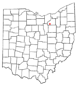
 Location of Lodi, Ohio | |
 Location of Lodi in Medina County | |
| Coordinates: 41°02′07″N 82°00′25″W / 41.03528°N 82.00694°W | |
| Country | United States |
| State | Ohio |
| County | Medina |
| Founded | 1811 |
| Incorporated | 1891 (village) |
| Government | |
| • Type | Mayor-Council |
| Area | |
| • Total | 2.26 sq mi (5.85 km2) |
| • Land | 2.25 sq mi (5.83 km2) |
| • Water | 0.01 sq mi (0.02 km2) |
| Elevation | 906 ft (276 m) |
| Population (2020) | |
| • Total | 2,746 |
| • Density | 1,219.90/sq mi (470.95/km2) |
| Time zone | UTC-5 (Eastern (EST)) |
| • Summer (DST) | UTC-4 (EDT) |
| ZIP code | 44254 |
| Area code | 330 |
| FIPS code | 39-44604[3] |
| GNIS feature ID | 2398466[2] |
| Website | www |
Lodi (/ˈloʊdaɪ/ LOH-dye[4]) is a village in Harrisville Township, Medina County, Ohio, United States. It is located southwest of the City of Medina along U.S. Route 42. As of the 2020 census, the population was 2,746.
- ^ "ArcGIS REST Services Directory". United States Census Bureau. Archived from the original on January 19, 2022. Retrieved September 20, 2022.
- ^ a b U.S. Geological Survey Geographic Names Information System: Lodi, Ohio
- ^ "U.S. Census website". United States Census Bureau. Archived from the original on July 9, 2021. Retrieved January 31, 2008.
- ^ "E.W. Scripps School of Journalism Ohio Pronunciation Guide | Ohio University". www.ohio.edu. Ohio University. 2016. Archived from the original on June 7, 2023. Retrieved January 2, 2024.