Loenhout | |
|---|---|
Village | |
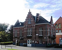
 Former town hall | |
| Coordinates: 51°23′57″N 4°38′38″E / 51.3992°N 4.6439°E | |
| Country | |
| Region | Flemish Region |
| Province | Antwerp |
| Municipality | Wuustwezel |
| Area | |
| • Total | 31.07 km2 (12.00 sq mi) |
| Highest elevation | 22 m (72 ft) |
| Lowest elevation | 13 m (43 ft) |
| Population (2021)[1] | |
| • Total | 4,411 |
| • Density | 140/km2 (370/sq mi) |
| Time zone | CET |
| Postal code | 2990 |
Loenhout is a village and deelgemeente (sub-municipality) of the municipality of Wuustwezel in the province of Antwerp, Belgium. The village is located near the Dutch border, and about 26 kilometres (16 mi) north-east of the city of Antwerp.[2]
- ^ a b "Bevolking per statistische sector - Sector 11053B". Statistics Belgium. Retrieved 10 May 2022.
- ^ "Distance Loenhout, Wuustwezel, BEL -> Antwerpen, BEL". Distance (in Dutch). Retrieved 10 May 2022.
