Loeriesfontein | |
|---|---|
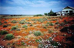
 Spring flowers attract visitors to Loeriesfontein in August and September | |
| Coordinates: 30°57′S 19°26′E / 30.950°S 19.433°E | |
| Country | South Africa |
| Province | Northern Cape |
| District | Namakwa |
| Municipality | Hantam |
| Area | |
| • Total | 34.46 km2 (13.31 sq mi) |
| Population (2011)[1] | |
| • Total | 2,744 |
| • Density | 80/km2 (210/sq mi) |
| Racial makeup (2011) | |
| • Black African | 2.0% |
| • Coloured | 86.3% |
| • Indian/Asian | 0.1% |
| • White | 11.0% |
| • Other | 0.7% |
| First languages (2011) | |
| • Afrikaans | 98.7% |
| • Other | 1.3% |
| Time zone | UTC+2 (SAST) |
| Postal code (street) | 8185 |
| PO box | 8185 |
| Area code | 027 |
Loeriesfontein is a small town in the Northern Cape of South Africa. It falls within what is known as the Hantam region.

- ^ a b c d "Main Place Loeriesfontein". Census 2011.

