Loleta, California
Swauger and Swauger's Station | |
|---|---|
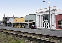
 Loleta's Main Street on south side of rail tracks | |
 Location of Loleta in Humboldt County, California. | |
| Coordinates: 40°38′27″N 124°13′31″W / 40.64083°N 124.22528°W | |
| Country | |
| State | |
| County | Humboldt |
| Area | |
| • Total | 2.125 sq mi (5.504 km2) |
| • Land | 2.125 sq mi (5.504 km2) |
| • Water | 0 sq mi (0 km2) 0% |
| Elevation | 46 ft (14 m) |
| Population | |
| • Total | 828 |
| • Density | 390/sq mi (150/km2) |
| Time zone | UTC-8 (Pacific (PST)) |
| • Summer (DST) | UTC-7 (PDT) |
| ZIP Code | 95551 |
| Area code | 707 |
| GNIS feature IDs | 1656137; 2611440 |
| U.S. Geological Survey Geographic Names Information System: Loleta, California; U.S. Geological Survey Geographic Names Information System: Loleta, California | |
Loleta (Wiyot: Guduwalhat)[4] is a unincorporated community in Humboldt County, California, United States.[2] Loleta is located 5.5 miles (9 km) south of Fields Landing,[5] and 15 miles (24 km) south of Eureka at an elevation of 46 feet (14 m).[2] The population was 783 at the 2010 census. For statistical purposes, the United States Census Bureau has defined Loleta as a census-designated place (CDP).[6] Residents live in a central community area and rural outskirts. There are two separate Native American reservations on the rural outskirts of Table Bluff, California.
The ZIP Code is 95551,[7] and the community is inside area code 707.
- ^ "2010 Census U.S. Gazetteer Files – Places – California". United States Census Bureau.
- ^ a b c U.S. Geological Survey Geographic Names Information System: Loleta, California
- ^ "Explore Census Data". data.census.gov. Retrieved May 5, 2023.
- ^ "Language – Wiyot Tribe". Archived from the original on February 13, 2012. Retrieved July 7, 2012.
- ^ Durham, David L. (1998). California's Geographic Names: A Gazetteer of Historic and Modern Names of the State. Clovis, Calif.: Word Dancer Press. p. 97. ISBN 1-884995-14-4.
- ^ U.S. Geological Survey Geographic Names Information System: Loleta, California.
- ^ "ZIP Code Lookup". usps.com. Archived from the original on January 1, 2008.
