Lopburee
ลพบุรี | |
|---|---|
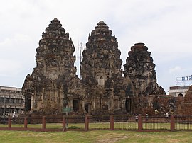
(Clockwise from top left) Ridge of Pa Sak Jolasid Dam, Ban Pa Wai railway station, King Narai's Palace, Phra Prang Sam Yot | |
| Nickname(s): Lavo (Thai: ละโว้) Mueang Ling (lit. City of Monkeys) | |
| Motto(s): วังนารายณ์คู่บ้าน ศาลพระกาฬคู่เมือง ปรางค์สามยอดลือเลื่อง เมืองแห่งดินสอพอง เขื่อนป่าสักชลสิทธิ์เกริกก้อง แผ่นดินทองสมเด็จพระนารายณ์ ("Home of King Narai Palace and San Phra Kan. The renowned Prang Sam Yot. City of Dinsophong chalk. Famous Pa Sak Jolasid Dam. The golden lad of King Narai.") | |
 Map of Thailand highlighting Lop Buri province | |
| Country | Thailand |
| Capital | Lopburi |
| Government | |
| • Governor | Niwat Rungsakorn |
| Area | |
| • Total | 6,200 km2 (2,400 sq mi) |
| • Rank | Ranked 36th |
| Population (2018)[2] | |
| • Total | 758,733 |
| • Rank | Ranked 32nd |
| • Density | 122/km2 (320/sq mi) |
| • Rank | Ranked 40th |
| Human Achievement Index | |
| • HAI (2022) | 0.6529 "somewhat high" Ranked 23rd |
| GDP | |
| • Total | baht 112 billion (US$3.6 billion) (2019) |
| Time zone | UTC+7 (ICT) |
| Postal code | 15xxx |
| Calling code | 036 |
| ISO 3166 code | TH-16 |
| Vehicle registration | ลพบุรี |
| Website | www |
Lopburi (Thai: ลพบุรี, RTGS: Lop Buri,[5] pronounced [lóp bū.rīː]) is a province in the central region of Thailand. The province is divided into 11 administrative districts, and Mueang Lopburi district is the capital. With over 750,000 people, the province is Thailand's 36th largest area and 32nd most populous. There are eight neighboring provinces, Phetchabun, Chaiyaphum, Nakhon Ratchasima, Saraburi, Phra Nakhon Si Ayutthaya, Ang Thong, Sing Buri, and Nakhon Sawan.
Lopburi is a significant province historically, where many historical structures, artifacts, and prehistoric settlements have been discovered. In the past, Lopburi was called by the name Lavo, after the Lavapuri, (present day Lahore) city named after the second son of Ram.The kingdom had been ruled by an absolute monarch.
- ^ Advancing Human Development through the ASEAN Community, Thailand Human Development Report 2014, table 0:Basic Data (PDF) (Report). United Nations Development Programme (UNDP) Thailand. pp. 134–135. ISBN 978-974-680-368-7. Retrieved 17 January 2016, Data has been supplied by Land Development Department, Ministry of Agriculture and Cooperatives, at Wayback Machine.
{{cite report}}: CS1 maint: postscript (link)[dead link] - ^ "รายงานสถิติจำนวนประชากรและบ้านประจำปี พ.ศ.2561" [Statistics, population and house statistics for the year 2018]. Registration Office Department of the Interior, Ministry of the Interior (in Thai). 31 December 2018. Retrieved 20 June 2019.
- ^ "ข้อมูลสถิติดัชนีความก้าวหน้าของคน ปี 2565 (PDF)" [Human Achievement Index Databook year 2022 (PDF)]. Office of the National Economic and Social Development Council (NESDC) (in Thai). Retrieved 12 March 2024, page 65
{{cite web}}: CS1 maint: postscript (link) - ^ "Gross Regional and Provincial Product, 2019 Edition". <>. Office of the National Economic and Social Development Council (NESDC). July 2019. ISSN 1686-0799. Retrieved 22 January 2020.
- ^ ประกาศราชบัณฑิตยสถาน เรื่อง การเขียนชื่อจังหวัด เขต อำเภอ และกิ่งอำเภอ (PDF). Royal Gazette (in Thai). 117 (พิเศษ 94 ง): 2. 14 September 2000. Archived from the original (PDF) on 25 January 2012.


