| Lord Howe Rise | |
|---|---|
| Stratigraphic range: | |
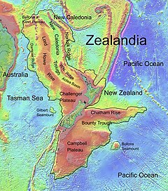
 The Lord Howe Rise is part of the continent known as Zealandia. | |
| Location | |
| Coordinates | 28°S 161°E / 28°S 161°E |
| Region | South Pacific, Coral Sea, Tasman Sea |
| Type section | |
| Named for | Lord Howe Island |
The Lord Howe Rise is a deep sea plateau which extends from south west of New Caledonia to the Challenger Plateau, west of New Zealand in the south west of the Pacific Ocean. To its west is the Tasman Basin and to the east is the New Caledonia Basin.[1] Lord Howe Rise has a total area of about 1,500,000 km2 (580,000 sq mi),[1] and generally lies about 750 to 1,200 metres under water.[2] It is part of Zealandia, a much larger continent that is now mostly submerged, and so is composed of continental crust. Some have included the 3,500 m (11,500 ft) deep New Caledonia Basin as within the rise, given its continental crust origin, and this would give a larger total area of 1,950,000 km2 (750,000 sq mi).[3]
- ^ a b "Lord Howe Rise". Regional petroleum geology of Australia. Geoscience Australia. 16 June 2003. Archived from the original on 13 March 2012. Retrieved 2007-04-19.
- ^ Harris, Peter T.; Scott L. Nichol; Tara J. Anderson; Andrew D. Heap (2011). "57: Habitats and Benthos of a Deep Sea Marginal Plateau, Australia". Seafloor Geomorphology As Benthic Habitat: GeoHAB Atlas of Seafloor Geomorphic Features and Benthic Habitats. Elsevier. p. 777. ISBN 978-0123851406. Retrieved 26 June 2013.
- ^ Przeslawski, Rachel; Williams, Alan; Nichol, Scott L.; Hughes, Michael G.; Anderson, Tara J.; Althaus, Franziska (2011). "Biogeography of the Lord Howe Rise region, Tasman Sea". Deep Sea Research Part II: Topical Studies in Oceanography. 58 (7–8): 959–969. Bibcode:2011DSRII..58..959P. doi:10.1016/j.dsr2.2010.10.051. ISSN 0967-0645.