This article's lead section may be too long. (August 2019) |
Los Cabos | |
|---|---|
|
Top: Arcos de Cabo San Lucas ; Middle: San José del Cabo, Cabo San Lucas:Sierra de la Laguna, Cabo Pulmo National Park | |
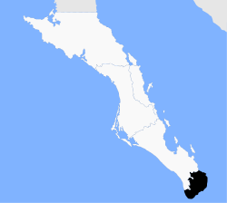
 Location of Los Cabos on Baja California Sur's tip. | |
| Country | Mexico |
| State | Baja California Sur |
| Municipal seat | San José del Cabo |
| Largest city | Cabo San Lucas |
| Area | |
| • Total | 3,750.93 km2 (1,448.24 sq mi) |
| Population (2020 Census) | |
| • Total | 351,111 |
| • Density | 94/km2 (240/sq mi) |
| Demonym | Cabeño(a) |
| Time zone | UTC−7 (Pacific (US Mountain)) |
| • Summer (DST) | UTC−6 (Pacific) |
Los Cabos (Spanish pronunciation: [los ˈkaβos]) is a municipality located at the southern tip of Mexico's Baja California Peninsula, in the state of Baja California Sur. It encompasses the two towns of Cabo San Lucas and San José del Cabo (the municipal seat) linked by a thirty-two-km Resort Corridor of beach-front properties and championship golf courses.[1]
The area was remote and rural until the latter 20th century, when the Mexican government began to develop Cabo San Lucas for tourism, which then spread east to the municipal seat. The main draw is the climate and geography, where desert meets the sea, along with sport fishing, resorts and golf. This tourism is by far the main economic activity with over two million visitors per year. Over 1 million visit from the United States.
Although San José del Cabo is the seat of government for the municipality of Los Cabos, it is smaller than the other city of Cabo San Lucas. However, because of federal and private investments in tourism, its growth is now rivaling that of the more famous resort area.[2][3]
This growth has been regulated to outside of the town centre, especially to the south where the beaches are, leaving the historic town centre quiet and relatively unchanged.[3][4] There are still cobblestone streets, adobe houses, jacaranda trees and a central square in front of a church that dates from the 18th century, where people gather in the evening when it is cooler.[3][4][5]
A number of the large houses in the center date from the 19th century, and most of these have been converted into restaurants, art galleries and shops selling everything from fine handcrafts, silver, local gemstones and souvenirs.[3][4][6] The art scene in the town is well-developed because of tourism and people with vacation homes. These shops carry high end paintings and sculptures from traditional Mexican, Mexican contemporary and international artisans and artists.[7]
During the high season from October to May, these galleries stay open late into the night.[5] The town has resisted the addition of large shopping malls and chain stores.[7] There is also some colonial era architecture as well, but this style has more in common with colonial towns to the north into the United States rather than the centre and south of Mexico.[8]
The main example of colonial architecture is the town's parish church. It was part of the Estero de las Palmas de San José del Cabo Mission, founded in 1730.[7][9] The facade is marked with a tile mural depicting the martyrdom of founder Nicolás Tamaral, killed by the local Pericu people .[8][9] The patron saint of the town is Saint Joseph, whose feast day is celebrated here on 19 March. Another important occasion is the feast of the Our Lady of the Pillar on 12 October. Occasions like these are marked with traditional dance in dress styles known as “Flor de Pitaya” and the “La Cuera.”[2][9]
Other important landmarks in the town include the municipal hall (palacio municipal), which dates from 1981 and the cultural centre or Casa de Cultura, housed in a 19th-century building.[8][9]
The tourist area of the town is the area between the town proper and the shoreline. This area has a nine-hole golf course and a line of hotels and resorts facing the ocean,[4] which served over 900,000 hotel guests in 2011.[10]
- ^ "Los Cabos is no longer a haven from Mexico's bloodshed". Los Angeles Times. ISSN 0458-3035. Archived from the original on 2018-01-20. Retrieved 2018-01-20.
- ^ a b "Los Cabos". Enciclopedia de los Municipios y Delegaciones de México. Mexico: INAFED. 2010. Archived from the original on April 2, 2015. Retrieved July 23, 2014.
- ^ a b c d John Howells and Don Merwin (2007). Choose Mexico for retirement. Guilford, CT: The Globe Pequot Press. p. 182. ISBN 9780762743926.
- ^ a b c d "San José del Cabo". Fodors. Archived from the original on July 28, 2014. Retrieved July 23, 2014.
- ^ a b Josh Noel (October 29, 2013). "Contrasting Cabos Take your pick of party or peace at the tip of Mexico's Baja California". Chicago Tribune. Archived from the original on July 24, 2014. Retrieved July 23, 2014.
- ^ Stephanie Kang (February 28, 2006). "Off the Beaten Track / San Jose del Cabo". Wall Street Journal, Eastern edition. New York. p. D7.
- ^ a b c Teresa Rodriguez Williamson (June 6, 2009). "Mexico is Ready for Primetime Part II". Huffington Post. Archived from the original on July 28, 2014. Retrieved July 23, 2014.
- ^ a b c Ricardo Diazmunoz and Maryell Ortiz de Zarate (March 12, 2000). "Encuentros con Mexico/ Sol, sol y sol (II)". Reforma. Mexico City. p. 2.
- ^ a b c d "Los Cabos: donde se unen los mares". Mexico City: Mexico Desconocido magazine. 20 May 2010. Archived from the original on July 29, 2014. Retrieved July 23, 2014.
- ^ "Ranking of World Tourism" (PDF) (in Spanish). Consejo de Promoción Turística de México. 2011. p. 2. Archived from the original (PDF) on February 24, 2022. Retrieved 3 September 2012.


