| Los Padres National Forest | |
|---|---|
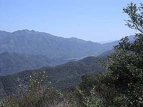
 Jameson Reservoir (center), Santa Ynez Mountains (right), Los Padres back country and Old Man Mountain (left), Reyes Peak (background). | |
 | |
| Location | California |
| Nearest city | Santa Barbara, Big Sur, Ojai, San Luis Obispo, Solvang and Santa Ynez[1] |
| Coordinates | 34°40′N 119°45′W / 34.667°N 119.750°W |
| Area | 2,970 sq mi (7,700 km2) |
| Established | December 1936 |
| Governing body | U.S. Forest Service |
| Website | Los Padres National Forest |


Los Padres National Forest is a United States national forest in southern and central California. Administered by the United States Forest Service, Los Padres includes most of the mountainous land along the California coast from Ventura to Monterey, extending inland. Elevations range from sea level to 8,847 feet (2,697 m).[2]
- ^ Los Padres National Forest: Recreation and Visitors Maps
- ^ "Mount Pinos". NGS Data Sheet. National Geodetic Survey, National Oceanic and Atmospheric Administration, United States Department of Commerce. Retrieved June 29, 2009.