Luapula | |
|---|---|
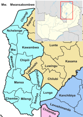
 Luapula Province showing its districts | |
| Country | |
| Capital | Mansa |
| Government | |
| • Type | Provincial Administration |
| • Provincial Minister | Derricky Chilundika (Formerly) |
| Area | |
• Total | 50,567 km2 (19,524 sq mi) |
| Population (2022 census) | |
• Total | 1,519,478 |
| • Density | 30/km2 (78/sq mi) |
| Time zone | UTC+2 |
| HDI (2018) | 0.520[1] low · 8th |
Luapula Province is one of Zambia's ten provinces located in the northern part of the country. Luapula Province is named after the Luapula River and its capital is Mansa. As per the 2022 Zambian census, the Province had a population of 1,519,478, which accounted for 7.72 per cent of the total Zambian population.[2]
The province has an international border along Democratic Republic of the Congo (DR Congo) and domestically extends along the northern and eastern banks of the Luapula river from Lake Bangweulu to Lake Mweru. The province is inhabited by Lunda, who are also the major tribe in the country. Bemba is one of the widely spoken languages in the province. The major economic activities are agriculture and fishing, with cassava being the major crop. Mutomboko ceremony is the most important festival celebrated. Lumangwe Falls, Mumbuluma Falls, Mumbotuta Waterfalls, Kundabwika Waterfalls and Chilongo Waterfalls are the major water falls.
The chief artery of the province is the Samfya-Mansa-Mwansabombwe-Nchelenge highway known informally as the Zambia Way. The province is bordered along the Luapula River, through Lake Mweru and to its north by DR Congo. Around 80.5 per cent of the population of Luapula is accounted as poor in 2010 census, making it the poorest of all provinces in Zambia. It has eight major attractions of the country among its waterfalls, wildlife and cultural heritage. Major mineral deposits found in the province are manganese, lime, copper and precious metals.
- ^ "Sub-national HDI - Area Database - Global Data Lab". hdi.globaldatalab.org. Retrieved 2018-09-13.
- ^ "Luapula (Province, Zambia) - Population Statistics, Charts, Map and Location". www.citypopulation.de. Retrieved 2024-01-28.