| Lugarno Sydney, New South Wales | |||||||||||||||
|---|---|---|---|---|---|---|---|---|---|---|---|---|---|---|---|
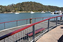
 Boardwalk and Lugarno Marina on Georges River | |||||||||||||||
 | |||||||||||||||
| Population | 5,869 (2021 census)[1] | ||||||||||||||
| Postcode(s) | 2210 | ||||||||||||||
| Elevation | 72 m (236 ft) | ||||||||||||||
| Location | 23 km (14 mi) south-west of Sydney CBD | ||||||||||||||
| LGA(s) | Georges River Council | ||||||||||||||
| State electorate(s) | Oatley | ||||||||||||||
| Federal division(s) | Banks | ||||||||||||||
| |||||||||||||||
Lugarno is a suburb situated in the St George area of southern Sydney, in the state of New South Wales, Australia. It is located in the local government area of the Georges River Council, 23 kilometres south of the Sydney central business district.
Situated on the northern bank of the Georges River, Lugarno is known for its large areas of bushland. Peakhurst and Peakhurst Heights, to the north, are the only adjoining suburbs. Nearby suburbs include Alfords Point, Illawong (on the other side of the Georges River), Padstow Heights (on the other side of Salt Pan Creek) and Oatley (on the other side of Lime Kiln Bay).
- ^ Australian Bureau of Statistics (28 June 2022). "Lugarno (State Suburb)". 2021 Census QuickStats. Retrieved 22 September 2024.