Lynxville, Wisconsin | |
|---|---|
 | |
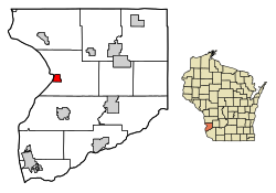
 Location of Lynxville in Crawford County, Wisconsin. | |
| Coordinates: 43°14′51″N 91°3′14″W / 43.24750°N 91.05389°W | |
| Country | |
| State | |
| County | Crawford |
| Area | |
| • Total | 1.37 sq mi (3.54 km2) |
| • Land | 1.35 sq mi (3.51 km2) |
| • Water | 0.01 sq mi (0.04 km2) |
| Elevation | 636 ft (194 m) |
| Population | |
| • Total | 132 |
| • Estimate (2019)[4] | 127 |
| • Density | 93.87/sq mi (36.23/km2) |
| Time zone | UTC-6 (Central (CST)) |
| • Summer (DST) | UTC-5 (CDT) |
| Area code | 608 |
| FIPS code | 55-46675[5] |
| GNIS feature ID | 1568849[2] |
Lynxville is a village in Crawford County, Wisconsin, United States. The population was 132 at the 2010 census.
- ^ "2019 U.S. Gazetteer Files". United States Census Bureau. Retrieved August 7, 2020.
- ^ a b "US Board on Geographic Names". United States Geological Survey. October 25, 2007. Retrieved January 31, 2008.
- ^ Cite error: The named reference
wwwcensusgovwas invoked but never defined (see the help page). - ^ Cite error: The named reference
USCensusEst2019CenPopScriptOnlyDirtyFixDoNotUsewas invoked but never defined (see the help page). - ^ "U.S. Census website". United States Census Bureau. Retrieved January 31, 2008.