| Lyons Ferry State Park | |
|---|---|
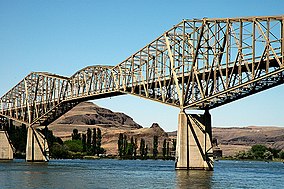
 Snake River Bridge, a major landmark of Lyons Ferry State Park | |
| Location | Franklin, Washington, United States |
| Coordinates | 46°37′15″N 118°14′04″W / 46.62083°N 118.23444°W[1] |
| Area | 168 acres (68 ha) |
| Elevation | 1,191 ft (363 m)[1] |
| Established | 1971 |
| Operator | Washington State Parks and Recreation Commission |
| Website | Lyons Ferry State Park |
Lyons Ferry State Park is a public recreation area located near the confluence of the Snake and Palouse rivers, seven miles (11 km) northwest of Starbuck, Washington. The state park is on Route 261, abreast of Lake Herbert G. West, a reservoir on the Snake River created with the construction in the 1960s of the Lower Monumental Dam some 17 miles (27 km) downstream. The park offers facilities for boating, fishing, and swimming.[2] The area is managed cooperatively by the Washington State Parks and Recreation Commission and the U.S. Army Corps of Engineers,[2] which operates the Lyons Ferry Marina.[3]
- ^ a b "Lyons Ferry State Park". Geographic Names Information System. United States Geological Survey, United States Department of the Interior.
- ^ a b Cite error: The named reference
waspwas invoked but never defined (see the help page). - ^ Cite error: The named reference
marina2was invoked but never defined (see the help page).

