| Lysakerelven Lysakerelva, Fåd (old Norse), meaning "border" | |
|---|---|
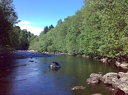
 A quiet section of the river | |
 | |
| Etymology | named after the farm Lysaker |
| Location | |
| Country | Norway |
| Region | Østlandet |
| District | Viken |
| Municipality | Oslo and Bærum |
| Physical characteristics | |
| Source | Bogstadvannet |
| • location | Oslo, Norway |
| • coordinates | 59°58′01″N 10°37′14″E / 59.9670622°N 10.6206894°E |
| • elevation | 145 m (476 ft) |
| Mouth | Lysakerfjorden |
• location | Lysaker, Akershus, Norway |
• coordinates | 59°54′41″N 10°38′30″E / 59.9114493°N 10.6417608°E |
• elevation | 0 m (0 ft) |
| Length | 7.4 km (4.6 mi) |
| Basin size | 178 km2 (69 sq mi) |
| Discharge | |
| • average | 4.0 m3/s (140 cu ft/s) |
| • minimum | 0.5 m3/s (18 cu ft/s) |
| • maximum | 80 m3/s (2,800 cu ft/s) |
| Basin features | |
| River system | Oslomarkvassdragene, more specifically Sørkedalsvassdraget |
Lysakerelven (also known as Lysakerelva, English: Lysaker River[1][2]) is a river in Norway that forms the boundary between the municipalities of the capital city of Oslo and Bærum.
The river by this name has its source in Bogstadvannet, though the source is further up, at Langlivann, and Søndre and Nordre Heggelivann in Oslomarka, the forests surrounding Oslo. Consequently, it is considered part of Oslomarkvassdragene, the river system flowing through these forests, and more specifically Sørkedalsvassdraget, the valley above Bogstadvannet. It flows out into Lysakerfjorden, part of Oslofjorden near Lysaker.[3][4]
- ^ Bjørgen, Anne Marit. 2011. The 2011 Norway Bed & Breakfast Book. Gretna: Pelican, p. 53.
- ^ Lloyd's Ports of the World 1999. 1998. London: LLP, p. 567
- ^ Sæther, Åsmund (2006-08-10). "Lysakerelva". Miljøstatus i Oslo og Akershus ("State of Environment in Oslo and Akershus") (in Norwegian). Oslo: Fylkesmannen i Oslo og Akershus. Archived from the original on 2011-07-24.
- ^ "Lysaker- og Sørkedalsvassdraget" (in Norwegian). Ullern: Municipality of Oslo - Recreational section. - main site for all matters related to Lysakerelva.