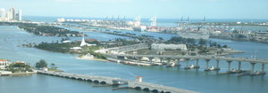
MacArthur Causeway County Causeway | |
|---|---|
 MacArthur Causeway, connecting Downtown Miami and South Beach | |
| Coordinates | 25°46′40″N 80°09′51″W / 25.777711°N 80.164233°W |
| Carries | 6 lanes of |
| Crosses | Biscayne Bay |
| Locale | Miami to Miami Beach |
| Official name | General Douglas MacArthur Causeway |
| Maintained by | FDOT |
| Characteristics | |
| Design | Causeway, beam, girder |
| Material | Slabs, girders, fill |
| Total length | 3.5 miles (5.6 km) |
| Longest span | 0.4 miles (0.64 km) |
| Clearance above | 68 feet (21 m) |
| History | |
| Designer | Frederic R. Harris, Inc., American Bridge Company |
| Opened | February 17, 1920[1] |
| Location | |
 | |
The General Douglas MacArthur Causeway is a six-lane causeway that connects Downtown Miami to South Beach via Biscayne Bay in Miami-Dade County.
The highway is the singular roadway connecting the mainland and beaches to Watson Island and the bay neighborhoods of Palm Island, Hibiscus Island, and Star Island. The MacArthur Causeway carries State Road 836 and State Road A1A over the Biscayne Bay via a girder bridge. Interstate 395 ends at Fountain Street, the entrance to Palm Island Park which has a traffic light as well as bus stops.
- ^ Lavender, Abraham (2002). Miami Beach in 1920. Mount Pleasant, SC: Arcadia Publishing. p. 160. ISBN 0-7385-2351-8.