| Macumba Treuer | |
|---|---|
 | |
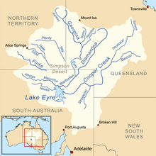
 Map of the Lake Eyre Basin showing the Macumba River | |
| Native name | |
| Location | |
| Country | Australia |
| State | South Australia |
| Physical characteristics | |
| Source | Macumba Hill |
| • elevation | 113 m (371 ft) |
| Mouth | Warburton River |
• elevation | −12 m (−39 ft) |
| Length | 233 km (145 mi) |
| Basin size | 39,000 km2 (15,000 sq mi) |
| Basin features | |
| River system | Lake Eyre Basin |
| Tributaries | |
| • left | Alberga River |
| [1][2] | |
Macumba River (Arabana: Maka-Wimpa; Arrernte: Ura-Ingka), once known as Treuer River,[2] is an ephemeral freshwater stream in the far north of South Australia, that is part of the Lake Eyre Basin.
- ^ "Map of Macumba River, SA". Bonzle Digital Atlas of Australia. 2012. Retrieved 18 January 2013.
- ^ a b Knibbs, G. H. (1909). Official Yearbook of the Commonwealth of Australia 1901-1908. Melbourne Victoria: Commonwealth Bureau of Census and Statistics.