| Maginot Line | |
|---|---|
Ligne Maginot | |
| Eastern France | |
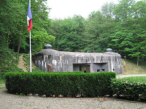
 Entrance to Ouvrage Schoenenbourg, Maginot Line in Alsace | |
 | |
| Type | Defensive line |
| Site information | |
| Controlled by | French Army |
| Open to the public | Only some sites |
| Condition | Mostly intact, due to the preservation of the French Government |
| Site history | |
| Built | 1929–1938 |
| Built by | Paul Painlevé, Colonel Tricaud
|
| In use | 1935–1969 |
| Materials | Concrete, steel, iron |
| Battles/wars | World War II
|
The Maginot Line (French: Ligne Maginot, [lˈiɲ maʒinˈo]),[a][1] named after the French Minister of War André Maginot, is a line of concrete fortifications, obstacles and weapon installations built by France in the 1930s to deter invasion by Nazi Germany and force them to move around the fortifications. It was impervious to most forms of attack; consequently, the Germans invaded through the Low Countries in 1940, passing it to the north. The line, which was supposed to be fully extended further towards the west to avoid such an occurrence, was finally scaled back in response to demands from Belgium. Indeed, Belgium feared it would be sacrificed in the event of another German invasion. The line has since become a metaphor for expensive efforts that offer a false sense of security.[2]
Constructed on the French side of its borders with Italy, Switzerland, Germany, Luxembourg and Belgium, the line did not extend to the English Channel. French strategy, therefore, envisioned a move into Belgium to counter a German assault. Based on France's experience with trench warfare during World War I, the massive Maginot Line was built in the run-up to World War II, after the Locarno Conference in 1925 gave rise to a fanciful and optimistic "Locarno spirit". French military experts believed the line would deter German aggression because it would slow an invasion force long enough for French forces to mobilise and counterattack.
The Maginot Line was invulnerable to aerial bombings and tank fire; it used underground railways as a backup. It also had state-of-the-art living conditions for garrisoned troops, supplying air conditioning and eating areas for their comfort.[3] French and British officers had anticipated the geographical limits of the Maginot Line; when Germany invaded the Netherlands and Belgium, they carried out plans to form an aggressive front that cut across Belgium and connected to the Maginot Line.
The French line was weak near the Ardennes. General Maurice Gamelin, when drafting the Dyle Plan, believed this region, with its rough terrain, would be an unlikely invasion route of German forces; if it were traversed, it would be done at a slow rate that would allow the French time to bring up reserves and counterattacks. The German Army, having reformulated their plans from a repeat of the First World War-era plan, became aware of and exploited this weak point in the French defensive front. A rapid advance through the forest and across the River Meuse encircled much of the Allied forces, resulting in a sizeable force having to be evacuated at Dunkirk and leaving the troops to the south unable to mount an effective resistance to the German invasion of France.[4]
Cite error: There are <ref group=lower-alpha> tags or {{efn}} templates on this page, but the references will not show without a {{reflist|group=lower-alpha}} template or {{notelist}} template (see the help page).
- ^ German and French IPA pronunciation retrieved from unalengua.com. 12 October 2024.
- ^ "Maginot Line (definition)". Merriam-Webster.com. Retrieved 2 January 2019.
a defensive barrier or strategy that inspires a false sense of security
- ^ Gravett 2007, p. 187.
- ^ Chelminski 1997, pp. 90–100.