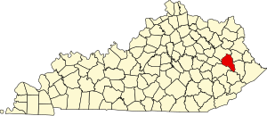
Magoffin County | |
|---|---|
 Magoffin County justice center in Salyersville | |
 Location within the U.S. state of Kentucky | |
 Kentucky's location within the U.S. | |
| Coordinates: 37°42′N 83°04′W / 37.7°N 83.06°W | |
| Country | |
| State | |
| Founded | 1860 |
| Named for | Beriah Magoffin |
| Seat | Salyersville |
| Largest city | Salyersville |
| Area | |
• Total | 309 sq mi (800 km2) |
| • Land | 308 sq mi (800 km2) |
| • Water | 0.7 sq mi (2 km2) 0.2% |
| Population (2020) | |
• Total | 11,637 |
• Estimate (2023) | 11,228 |
| • Density | 38/sq mi (15/km2) |
| Time zone | UTC−5 (Eastern) |
| • Summer (DST) | UTC−4 (EDT) |
| Congressional district | 5th |
| Website | magoffincounty |
Magoffin County is a county located in the U.S. state of Kentucky. As of the 2020 census, the population was 11,637.[1] Its county seat is Salyersville.[2] The county was formed in 1860 from adjacent portions of Floyd, Johnson, and Morgan Counties. It was named for Beriah Magoffin who was Governor of Kentucky (1859–62).[3][4]
- ^ "Census - Geography Profile: Magoffin County, Kentucky". United States Census Bureau. Retrieved December 30, 2022.
- ^ "Find a County". National Association of Counties. Retrieved June 7, 2011.
- ^ E., Kleber, John; Kentucky, University Press of; Policy, Institute for Regional Analysis and Public; Library, Camden-Carroll; University, Morehead State (January 1, 2000). "The Kentucky Encyclopedia".
{{cite web}}:|last3=has generic name (help)CS1 maint: multiple names: authors list (link) - ^ The Register of the Kentucky State Historical Society, Vol. 1. Kentucky State Historical Society. 1903. p. 36.