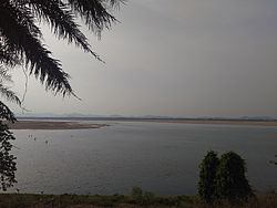
| Mahanadi River | |
|---|---|
 Mahanadi in Odisha | |
| Location | |
| Country | India |
| Parts | Chhattisgarh, Odisha |
| Region | Dandakaranya, Dakshina Kosala kingdom, Coastal plains |
| Administrative areas | Raipur, Janjgir, Raigarh,(Chhattisgarh), Sambalpur, Bargarh, Subarnapur, Boudh, Anugul, Cuttack, Banki, Jagatsinghpur, Nayagarh, Jharsuguda (Odisha) |
| Cities | Rajim, Sambalpur, Cuttack, Sonepur, Kantilo, Boudh, Banki, Paradeep |
| Physical characteristics | |
| Source | |
| • location | Nagri-Sihawa, Dhamtari, Dandakaranya, Chhattisgarh, India |
| • coordinates | 20°07′N 81°55′E / 20.11°N 81.91°E |
| • elevation | 890 m (2,920 ft) |
| Mouth | |
• location | False Point, Jagatsinghpur, Delta, Odisha, India |
• coordinates | 20°17′43″N 86°42′39″E / 20.29528°N 86.71083°E |
• elevation | 0 m (0 ft) |
| Length | 900 km (560 mi)[1] |
| Basin size | 132,100 km2 (51,000 sq mi)[1] |
| Discharge | |
| • location | False Point, Odisha |
| • minimum | 31.9 m3/s (1,125 cu ft/s)[2] |
| • maximum | 56,700 m3/s (2,000,000 cu ft/s)[2] |
| Basin features | |
| Tributaries | |
| • left | Seonath, Mand, Ib, Hasdeo, Kelo, Sapua |
| • right | Ong, parry, Jonk, Telen, Jira (Jeera), Danta |
The Mahanadi River is a major river in East Central India. It drains an area of around 132,100 square kilometres (51,000 sq mi) and has a total length of 900 kilometres (560 mi). Mahanadi is also known for the Hirakud Dam[1] which was the first major multipurpose river valley project after India's independence in 1947. The river flows through the states of Chhattisgarh and Odisha, before finally ending in the Bay of Bengal.
